옐로 스톤 국립 공원 이다 미국 국립공원 그리고 유네스코 세계문화유산. 그것은 세계 최초의 국립 공원으로 1872년에 엄청난 수의 간헐천을 보존하기 위해 지정되었습니다. 온천, 및 기타 열 지역은 물론이 지역의 놀라운 야생 동물과 험준한 아름다움을 보호합니다. 공원에는 3,472제곱마일(8,990km)이 있습니다.2), 대부분 내 북서 코너 와이오밍, 그러나 부분은 다음 상태로 확장됩니다. 아이다호 과 몬태나.
이해하다

역사
1872년 3월 1일 옐로스톤은 최초의 국립 공원 율리시스 S. 그랜트 회장이 세계 어느 곳에서나 선언한 보호 구역. 1978년에 지정되었다. 세계유산. 일반적으로 공원 이름은 옐로스톤의 그랜드 캐년에서 볼 수 있는 노란 바위의 이름을 따서 명명되었다고 가정하지만 공원 이름은 옐로스톤 강이 흐르는 옐로스톤 강에서 따온 것입니다. 동부 몬태나.
옐로스톤에 기록된 인류의 역사가 기록되기 훨씬 이전에 대규모 화산 폭발로 인해 엄청난 양의 화산재가 미국 서부 전체, 중서부 대부분, 미국 동부 해안 일부, 멕시코 북부, 캐나다 일부 지역을 뒤덮었습니다. 이 분화로 약 34 x 45마일(55 x 72km)의 칼데라가 남게 되었습니다. 보다 화산 배경용; 옐로스톤은 다음과 같이 분류됩니다. 초화산 그리고 그것의 마지막 분화는 VEI-8 이벤트 1000km 이상3 1980년 분출보다 1000배 더 강력한 분출 산. 세인트헬렌스. 옐로스톤 슈퍼 화산은 600,000~900,000년마다 분출하는 것으로 알려져 있으며 마지막 이벤트는 640,000년 전에 발생했습니다. 그것의 분출은 지구상에서 발생한 것으로 알려진 가장 큰 것 중 하나이며, 그 여파로 급격한 기후 변화를 일으키고 있습니다.
경치
지구 지열 특징의 절반을 가진 옐로스톤은 간헐천, 온천, 진흙 웅덩이 및 분기공의 행성에서 가장 다양하고 온전한 컬렉션을 보유하고 있습니다. 300개 이상의 간헐천이 지구에서 발견되는 간헐천의 3분의 2를 차지합니다. 여기에 화려한 색상의 온천, 부글부글 끓는 진흙탕, 김이 나는 분기구로 구성된 10,000개 이상의 열 기능을 결합하면 다른 곳과 비교할 수 없는 장소가 됩니다.
옐로스톤의 열수 특징은 엄청난 열을 방출하는 기본 마그마 덩어리가 없었다면 존재하지 않았을 것입니다. 그들은 또한 옐로스톤 고원을 둘러싼 산과 같은 수원에 의존합니다. 그곳에서 눈과 비는 균열로 가득 찬 침투성 암석 층을 통해 천천히 스며듭니다. 이 차가운 물의 일부는 얕은 마그마체에 의해 직접 가열된 뜨거운 소금물과 만납니다. 물의 온도는 끓는점보다 훨씬 높게 상승하지만 위의 물의 큰 압력과 무게로 인해 물은 액체 상태로 남아 있습니다. 그 결과 온도가 400°F(200°C)를 초과하는 과열된 물이 생성됩니다.
과열된 물은 주위에 가라앉는 더 차갑고 무거운 물보다 밀도가 낮습니다. 이것은 더 가볍고 더 부력이 있으며 과열된 물이 유문암 용암 흐름을 통해 균열과 약한 영역을 따라 표면으로 다시 여행을 시작할 수 있도록 하는 대류를 생성합니다. 이 위쪽 경로는 공원의 열수 기능에 대한 자연적인 "배관" 시스템입니다. 표면에 도달하면 수영장의 다양한 색상은 다양한 온도에서 자라는 다양한 유형의 박테리아 때문입니다.
동식물

공원은 지구상에 남아 있는 가장 큰 온대 생태계 중 하나인 그레이터 옐로스톤 생태계의 핵심이며 결과적으로 야생 동물 관찰을 위한 탁월한 지역입니다.
옐로스톤은 하위 48개 주에서 포유류가 가장 많이 서식하는 곳입니다. 회색곰과 흑곰을 포함하여 67종의 포유류가 이곳에 살고 있습니다. 회색 늑대는 1926년까지 사냥되어 멸종되었지만 1995년에 캐나다에서 다시 도입되었으며 현재 100마리 이상이 공원에 살고 있어 야생에서 그들을 볼 수 있는 최고의 장소 중 하나입니다. 또한, 공원은 번성하는 코요테와 붉은 여우의 서식지이기도 합니다. 대규모의 방해받지 않는 서식지가 필요한 울버린과 스라소니도 옐로스톤 생태계에서 발견됩니다. 엘크, 노새 사슴, 들소, 큰사슴, 큰뿔양, 대뿔사슴, 흰꼬리사슴 등 7종의 유제류가 이곳에 살고 있습니다. 토착산이 아닌 산양이 공원 북부에 서식했으며 비버를 비롯한 수많은 작은 포유동물이 공원 전체에서 발견됩니다.
옐로스톤은 1872년 설립된 이래로 조류 관찰 기록을 보관하고 있습니다. 이 기록에는 현재까지 330종의 새가 기록되어 있으며 그 중 약 148종이 공원에 둥지를 틀고 있는 것으로 알려져 있습니다. 공원 내에서 발견되는 고도의 변화와 광범위한 서식지 유형은 이 지역의 상대적으로 높은 다양성에 기여합니다.
빙하 활동과 현재의 시원하고 건조한 조건은 공원에서 발견되는 상대적으로 적은 수의 파충류와 양서류에 대한 책임이 있습니다.
옐로스톤에는 1,350종 이상의 관다발 식물이 있으며 그 중 218종이 외래종입니다.
기후
| 옐로 스톤 국립 공원 | ||||||||||||||||||||||||||||||||||||||||||||||||||||||||||||
|---|---|---|---|---|---|---|---|---|---|---|---|---|---|---|---|---|---|---|---|---|---|---|---|---|---|---|---|---|---|---|---|---|---|---|---|---|---|---|---|---|---|---|---|---|---|---|---|---|---|---|---|---|---|---|---|---|---|---|---|---|
| 기후 차트(설명) | ||||||||||||||||||||||||||||||||||||||||||||||||||||||||||||
| ||||||||||||||||||||||||||||||||||||||||||||||||||||||||||||
| ||||||||||||||||||||||||||||||||||||||||||||||||||||||||||||
옐로스톤 국립공원의 날씨는 화창하고 따뜻하다에서 춥고 비가 오는 날씨로 매우 빠르게 변할 수 있으므로 필요에 따라 사용할 수 있는 여분의 의복을 가져오는 것이 중요합니다. 옐로스톤에는 연중 언제든지 눈이 내릴 수 있습니다.
- 여름: 낮 기온은 종종 화씨 70도(화씨 25도)이고 낮은 고도에서는 화씨 30도(섭씨 30도)입니다. 밤에는 일반적으로 시원하고 더 높은 고도에서는 기온이 영하로 떨어질 수 있습니다. 천둥 번개는 오후에 일반적입니다.
- 겨울: 온도는 하루 종일 영하 20°F(-20°C ~ -5°C) 범위입니다. 밤새 영하의 온도가 일반적입니다. 기록적인 최저 온도는 -66°F(-54°C)입니다. 강설량은 매우 다양합니다. 평균은 연간 150인치(3,800mm)이지만 더 높은 고도에서 그 양의 두 배를 얻는 것은 드문 일이 아닙니다.
- 봄 & 가을: 주간 온도 범위는 30~60도(0~20°C)이며 야간 최저 기온은 10대에서 한 자릿수(-5~-20°C)입니다. 봄과 가을에는 24시간 동안 12인치의 정기적으로 눈이 내리는 것이 일반적입니다. 일년 중 언제든지 갑작스러운 변화에 대비하십시오. 무엇보다 예측할 수 없는 것이 옐로스톤 날씨의 특징입니다. 다양한 의류 옵션 여름에도 따뜻한 재킷과 우비를 가져오십시오.
들어와

비행기로
옐로스톤을 제공하는 주요 공항은 다음과 같습니다. 잭슨 홀 공항 (JAC IATA), 에 그랜드 티턴 국립공원, 근처에 잭슨, 그리고 가장 큰 공항 와이오밍. 유나이티드와 델타항공은 연중 내내 잭슨 홀 서비스를 제공합니다. 덴버 과 솔트 레이크시 각기. 이 항공사와 American 및 Frontier는 해당 도시와 미국 전역의 다른 8개 도시에서 계절 항공편을 제공합니다.
상업 서비스를 제공하는 기타 공항은 다음과 같습니다.
- 청구서 (몬타나) (빌 IATA). 수많은 도시에서.
- 보즈먼 (몬타나) (BZN IATA). 8개 도시에서 일년 내내 그리고 계절에 따라 더 많이 제공됩니다.
- 코디 (와이오밍) (대구 IATA), 옐로스톤 지역 공항. 솔트레이크시티와 덴버에서.
- 아이다호 폭포 (아이다호) (아이다 IATA). 6개 도시에서.
- 솔트 레이크시 (유타) (에스엘씨 IATA). 자동차로 6시간 정도 거리에 있지만 여전히 공원에서 가장 가까운 주요 공항으로 전국 주요 도시에서 출발하는 항공편과 제한된 국제선 항공편이 있습니다.
- 웨스트 옐로스톤 (몬타나) (WYS IATA). 6~9월 솔트레이크시티에서만.
자동차로
공원에는 5개의 입구가 있습니다. 각 입구에서 가장 가까운 도시가 표시됩니다.
- 1 북쪽 - 에서 액세스 가디너(몬태나) 에서 US Route 89 경유, 90km 리빙스턴. 이 입구는 일년 내내 열려 있으며 다음 위치에 있는 공원 본부로 연결됩니다. 매머드 온천, 공원 경계 내부 8.0km. 아이코닉한 루즈벨트 아치 이 입구에 있습니다.
- 2 북동 - 에서 액세스 실버 게이트 과 쿡 시티 US Route 212(베어투스 하이웨이)를 통해. 쿡시티 입구와 도로는 연중 개방되지만 쿡시티를 지나는 212번 국도는 겨울(10월 중순~5월 말)에는 폐쇄된다.
- 3 동쪽 - 에서 액세스 코디, 85km(53마일), 미국 국도 14/16/20 경유. 이 입구는 겨울(11월 초순~5월 초순)에는 폐쇄됩니다.
- 4 남쪽 - 에서 액세스 그랜드 티턴 국립공원 미국 국도 89/191/287을 통해. 이 입구는 겨울(11월 초순~5월 중순)에는 폐쇄됩니다.
- 5 서쪽 - 에서 액세스 웨스트 옐로스톤 US Route 20/191/287 경유, 97km(60마일) 애쉬튼, 아이다호. 이 입구는 겨울(11월 초순~4월 하순)에는 폐쇄됩니다.
도보로
3,100마일(5,000km) 길이의 산책로를 포함하여 사방에 공원으로 들어가는 수많은 산책로가 있습니다. 콘티넨탈 디바이드 트레일.
수수료 및 허가증
공원에 입장하는 모든 차량과 개인은 7일 동안 유효한 입장료를 지불해야 합니다. 2020년 기준 수수료는 다음과 같습니다.
- $20 - 도보, 자전거 등 개인
- $30 - 오토바이 또는 스노모빌.
- $35 - 비상업용 차량.
- $70 - 옐로스톤 국립공원 연간 패스로 개인 차량으로 1년 동안 공원을 이용할 수 있습니다.
과거에는 옐로스톤 입장료에도 입장료가 포함되어 있었습니다. 그랜드 티턴 국립공원, 두 공원을 모두 방문할 계획인 방문자는 이제 각각에 대해 별도의 입장료를 지불해야 합니다.
여러 가지가 있습니다 패스 옐로스톤 국립공원과 모든 국립공원, 일부 국립 기념물, 국립 야생 동물 보호 구역, 국유림에 무료로 입장할 수 있는 개인 차량 또는 도보/자전거로 함께 여행하는 단체의 경우:
- $80 연간 패스 (발행일로부터 12개월 동안 유효) 누구나 구매할 수 있습니다. 군인은 CAC(Common Access Card) 또는 군인 신분증을 제시하면 무료 출입증을 얻을 수 있습니다.
- $80 시니어 패스 (소유자의 평생 유효)는 미국 시민 또는 62세 이상의 영주권자에게 제공됩니다. 신청자는 시민권과 나이에 대한 문서를 제공해야 합니다. 이 패스는 또한 일부 공원 편의 시설에 대해 50% 할인을 제공합니다. 고령자는 연간 이용권 $20도 받을 수 있습니다.
- 무료 액세스 패스 (소유자의 평생 유효)는 미국 시민 또는 영구 장애가 있는 영주권자에게 제공됩니다. 신청자는 시민권 및 영구 장애 문서를 제공해야 합니다. 이 패스는 또한 일부 공원 편의 시설에 대해 50% 할인을 제공합니다.
- 무료 자원봉사 패스 Interagency Pass Program에 참여하는 연방 기관에서 250시간 이상 자원 봉사한 개인에게 제공됩니다.
- 무료 연간 4학년 패스 (4학년 9월-8월에 유효) 개인 비상업 차량으로 소지인 및 동반 승객이 입장할 수 있습니다. 등록 모든 어린이 야외 활동 웹사이트가 필요합니다.
국립 공원 관리국은 매년 5일 동안 모든 국립 공원에 무료 입장을 제공합니다.
- Martin Luther King Jr. Day(1월 세 번째 월요일); 다음 준수일은 2021년 1월 18일입니다.
- 국립공원주간 첫날(4월 셋째주 토요일) 다음 준수는 2021년 4월 17일입니다.
- 국립 공원 서비스 생일(8월 25일)
- 국가 공유지의 날(9월 네 번째 토요일); 다음 준수일은 2021년 9월 25일입니다.
- 재향 군인의 날(11월 11일)
주위를

방향을 잡는 유용한 방법은 옐로스톤 내부의 도로를 "8자형" 모양으로 시각화하는 것입니다. 아래쪽 루프인 West Thumb - Old Faithful - Madison - Norris - Canyon - Lake Village - West Thumb은 약 140km입니다. 상부 루프인 Norris - Mammoth - Tower-Roosevelt - Canyon - Norris는 약 70마일(110km)입니다. 공원은 큰.
자동차로
대부분의 방문객들은 옐로스톤 국립공원 내부를 돌아다닐 때 개인 차량을 이용합니다. 사람들이 야생 동물을 보기 위해 멈출 때마다 도로가 매우 혼잡해질 수 있습니다. 풀아웃을 사용하고 다른 운전자를 존중하여 곰잼. 눈이 내리면 도로가 폐쇄될 수 있으며 겨울철에는 많은 공원 도로가 영구적으로 폐쇄됩니다.
버스로
공원 내에는 대중교통이 없습니다. 잔테라 리조트 여름 시즌에는 공원 내 버스 투어를 제공합니다. 로워 루프 투어는 파크 남부 지역에서만 출발합니다. 어퍼 루프 투어는 레이크 호텔, 피싱 브리지 RV 파크, 캐년 롯지에서 출발하여 공원의 북쪽 부분만 둘러볼 수 있습니다. Grand Loop Tour는 Gardiner와 Mammoth Hot Springs Hotel에서 출발하여 하루 만에 전체 공원을 둘러볼 수 있습니다. 겨울철에는 다양한 장소에서 스노우 코치 투어가 제공됩니다. 정보나 예약은 1 307 344-7311로 전화주세요.
또한, 여름 시즌 동안 상업 비즈니스는 많은 지역 마을과 도시에서 출발하는 투어를 제공합니다. 겨울철에 일부 사업체에서는 대부분의 공원 도로에서 스노코치 투어를 제공하거나 Mammoth Hot Springs에서 Cooke City 도로로 가는 버스 교통편을 제공합니다.
자전거로
사이클링 공원에서 보내는 것은 매우 보람 있는 경험이 될 수 있지만, 공원과의 거리가 멀기 때문에 매일 밤 숙박이 가능하도록 몇 가지 추가 계획이 필요합니다. 공원에는 자전거 타는 사람들을 위한 캠핑장이 여러 개 있지만, 성수기에는 가능한 한 미리 사이트를 예약하는 것이 가장 좋습니다.
스노모빌 또는 스노코치 이용
겨울은 방문자가 가장 적은 공원을 방문하기에 가장 고요한 시기일 것입니다. 스노모빌과 스노코치 여행의 겨울 이용 시즌은 12월 중순에 시작하여 3월 중순에 끝납니다. 폭설 여행의 실제 개장 또는 폐쇄 날짜는 입구에 따라 다르며 적절한 스노우팩 및 제설 일정에 따라 결정됩니다. 스노모빌이나 스노코치를 타고 공원을 방문하려는 방문객은 상업용 스노코치로 여행하거나 대부분의 입구에서 이용할 수 있는 스노모빌(개인, 가이드가 없는 스노모빌 또는 스노코치는 허용되지 않음)로 상업 가이드를 동반해야 합니다. 베스트 가용 기술 스노모빌이 필요하며 스노모빌과 스노코치 입장에는 일일 제한이 있습니다. 스노모빌과 스노 코치의 오프로드 사용은 금지되어 있습니다.
보다

옐로스톤은 자연 유산과 아름다움으로 세계적으로 유명하며, 10,000개 이상의 사례와 함께 세계 지열 특징의 절반을 보유하고 있습니다. 옐로스톤을 여행하는 사람들은 300개 이상의 간헐천(예: "Old Faithful"), 끓는 진흙 웅덩이, 그리즐리 베어, 늑대, 들소, 엘크와 같은 놀라운 야생 동물 집합을 지구 표면에 서 있는 동안 모두 볼 수 있습니다. 가장 큰 알려진 "슈퍼 화산".
공원은 동쪽에서 시작하여 시계 방향으로 공원을 여행하는 사람이 마주치게 되는 대략 8개의 주요 영역으로 세분될 수 있습니다.
브리지 베이, 피싱 브리지 및 호수
이 세 지역은 옐로스톤 호수의 북쪽에 있습니다. 레크레이션 옵션에는 보트 타기, 낚시 및 소수의 온열 기능이 포함됩니다.
이 지역의 열적 특징과 자연 명소는 다음과 같습니다.
- 1 옐로스톤 호수. 132평방마일(340평방킬로미터)의 표면적을 가진 옐로스톤 호수는 북미에서 가장 높은 고도(7,000피트 이상)의 호수입니다. 해발 7,733피트(2,357m)에 위치한 천연 호수입니다. 길이는 약 32km, 너비는 24km이며 해안선은 141마일(227km)입니다. 거의 반년 동안 동결됩니다. 12월 말이나 1월 초에 얼고 5월 말이나 6월 초에 해동합니다.


- 헤이든과 펠리컨 계곡. Hayden Valley는 Fishing Bridge Junction에서 북쪽으로 9.7km 떨어져 있습니다. Pelican Valley는 Fishing Bridge에서 동쪽으로 4.8km 떨어져 있습니다. 이 두 개의 광대한 계곡은 48개 주에서 회색곰, 들소, 엘크 및 기타 야생 동물을 위한 최고의 서식지로 구성되어 있습니다.
- 2 내츄럴 브릿지 (브리지 베이 캠프그라운드 바로 남쪽). 이 암석층은 1마일(1.6km)의 쉬운 도보를 통해 접근할 수 있으며 다리로 이어지는 자전거 도로도 있습니다. Natural Bridge는 Bridge Creek에 의해 유문암 노두가 침식되어 형성되었습니다. 다리의 꼭대기는 개울 위 약 51피트(16m)에 있습니다. 짧은 스위치백 트레일이 정상으로 이어지지만 현재는 이 기능을 보호하기 위해 다리를 건너는 것이 금지되어 있습니다.
- 3 르하디 래피즈 (피싱 브리지에서 북쪽으로 4.8km). LeHardy Rapids는 옐로스톤 강의 폭포입니다. 지형학적으로 이곳이 호수가 끝나고 하천이 북상하는 실제 지점으로 생각된다. 봄에는 많은 송어가 얕은 웅덩이에서 쉬고 있는 것을 볼 수 있습니다. 그 후에는 Fishing Bridge 아래에서 산란을 위해 급류를 뛰어오르기 위해 에너지를 폭발시킵니다. 1984년에 지어진 산책로가 이 지역에 접근할 수 있게 해주지만 이 민감한 새 서식지를 보호하기 위해 봄 둥지 시즌에는 폐쇄됩니다.
- 4 진흙 화산. 이것은 한때 분화 중에 근처 나무에 진흙을 던질 수 있는 언덕 꼭대기의 열 특징이었지만 특히 큰 분화는 진흙 화산을 날려버렸고 언덕 기슭에 뜨겁고 부글거리는 진흙 웅덩이를 남겼습니다. 이 지역으로의 접근은 주차장에서 장애인이 접근할 수 있는 용의 입과 진흙 화산을 지나는 짧은 순환로와 비교적 가파른 사워 호수와 흑룡의 가마를 경유하는 0.5마일(800m) 위쪽 순환 산책로를 통해 이루어집니다. . 1994년 12월 이후 활동이 눈에 띄게 감소했지만 리드미컬한 증기의 트림과 번쩍이는 물의 혀로 인해 Dragon's Mouth Spring이라는 이름이 붙여졌습니다. Black Dragon's Caldron은 1948년 풍경에 폭발하여 나무의 뿌리를 날려버리고 주변을 덮었습니다. 진흙이 있는 숲. 1995년 1월, 진흙 간헐천의 남쪽 제방에 새로운 기능이 활성화되어 20 x 8피트(6.1m × 2.4m)의 면적을 포함하고 분기공, 작은 웅덩이 및 프라이팬 유형 기능으로 구성되었습니다. "Gumper"로 알려진 거대한 끓는 진흙 냄비를 포함하여 진흙 화산 지역의 가장 극적인 특징은 보드워크 레인저가 안내하는 산책을 통해서만 대중에게 공개됩니다.
- 5 유황 가마솥. 유황 가마솥 지역은 Mud Volcano의 바로 북쪽에 있는 준비 지역에서 볼 수 있습니다. 유황 가마솥의 노란색, 격렬하게 튀는 물은 pH 1.3으로 공원에서 가장 산성입니다. 이 전망대에서 볼 수 있는 다른 특징은 Turbulent Pool(더 이상 "난기류"가 아님)과 크고 활동적인 진흙 냄비의 분화구입니다.
이 지역의 역사 및 교육 명소는 다음과 같습니다.
- 6 낚시대. 원래 다리는 1902년에 현재 다리와 약간 다른 정렬을 가진 거친 코듀로이 통나무 다리로 지어졌습니다. 기존의 다리는 1937년에 지어졌습니다. Fishing Bridge는 역사적으로 매우 인기 있는 낚시 장소였습니다. 다리에서의 낚시는 참돔 송어의 주요 산란 지역이라는 사실 때문에 꽤 좋았습니다. 그러나 1973년에 인명피해가 줄어들면서 다리는 어업이 금지되었습니다. 그 이후로 이곳은 물고기를 관찰할 수 있는 인기 있는 장소가 되었습니다.
- 7 피싱 브리지 박물관 및 방문자 센터. 어교 박물관은 1931년에 완공되었으며 결국 전국 공원에서 소박한 건축물의 원형이 되었습니다. 1987년에 국가 사적으로 지정되었습니다. 자동차가 공원을 통과하는 주요 교통 수단으로 역마차를 대체하면서 더 이상 사람들이 가이드를 동반하지 않게 되면서 박물관은 방문객들이 정보를 얻을 수 있는 "산책로 박물관"으로 건립되었습니다. 옐로스톤에 대해 스스로.
- 8 레이크 옐로스톤 호텔. Lake Yellowstone Hotel은 인디언, 사냥꾼, 산악인의 만남의 장소로 오랫동안 알려진 장소에 1891년에 문을 열었습니다. 그 당시에는 북태평양 철도가 자금을 조달한 여느 철도 호텔과 다를 바 없을 정도로 특별하지 않았습니다. 1903년에 개조되었으며 1929년에 추가 변경이 이루어졌습니다. 1970년대까지 호텔은 심각한 파손에 빠졌습니다. 1981년, 국립 공원 관리국과 공원 영업권자인 TW Recreational Services는 1920년대의 영광스러운 당시의 모습으로 Lake Hotel을 복원하기 위한 10년 프로젝트에 착수했습니다. 이 공사는 1991년 호텔 100주년 기념 행사를 위해 완료되었습니다. 호텔은 그 해에 국가 사적지로 지정되었습니다.
- 9 레이크 레인저 역. 옐로스톤에서 10년 동안 군사 행정을 실시한 후 의회는 1916년 국립공원관리국을 창설했습니다. 순찰소는 공원 전체에 걸쳐 군인 기지를 대체하기 시작했습니다. Lake Ranger 역은 1923년에 완공되었습니다. 최초의 국립 공원 관리국(National Park Service) 국장인 Steven Mather는 역이 자연 및 문화 환경과 조화를 이루어야 한다고 제안했습니다. 지역의 한 나무꾼은 선구적인 건축 기술을 사용하여 역에 "트래퍼 캐빈" 스타일을 부여했습니다. 공원 건축가들과 함께 Horace Albright 교육감은 중앙에 돌 벽난로가 있는 큰 팔각형 "커뮤니티 룸"을 설계했습니다. 이 소박한 홀은 낮에는 정보 제공 기능을 하고 저녁에는 장작불 주위에 사람들이 모이는 장면이 되었습니다.
- 10 레이크 로지. 1915년 공원에 자동차가 등장하면서 많은 방문객이 몰렸습니다. Lake Hotel의 고급스러움과 텐트 캠프의 소박한 숙박 시설 사이에 중간 스타일의 숙박 시설이 필요했습니다. 1926년에 공원에 있는 4개의 롯지 중 하나인 Lake Lodge(Robert Reamer 디자인)가 완성되었습니다. 공원은 더 이상 부유한 "친구"나 왕성한 "쑥쑥"만 접근할 수 없었습니다.
웨스트 썸 앤 그랜트 빌리지

이 두 마을은 옐로스톤 호수의 서쪽에 있으며 보트 타기, 낚시, 그리고 호수로 직접 솟아오르는 온천인 "피싱 콘(Fishing Cone)"을 포함한 흥미로운 온천 시설을 제공합니다. 이 지역의 이름은 옐로스톤 호수가 약간의 상상을 하면 왼손이 남쪽으로 뻗어 있는 것처럼 보이고 이 지역이 그 손의 "엄지손가락"이 될 것이라는 사실에서 유래했습니다.
이 지역의 열적 특징과 자연 명소는 다음과 같습니다.
- 11 옐로스톤 호수. Lake Village 및 Fishing Village와 같이 이 지역은 북미 최대의 고지대 호수에 대한 접근을 제공합니다. 호수의 최상층은 19°C(66°F)를 거의 초과하지 않으며 하부층은 훨씬 더 춥습니다. 물이 매우 차가우므로 수영을 권장하지 않습니다.
- 12 서쪽 엄지 간헐천 분지. 이 간헐천 분지는 2마일(3.2km)의 거리를 따라 해안을 따라 위치하고 있으며, 이 간헐천에서 약 500야드(460m), 아마도 수 피트 정도 호수로 뻗어 있습니다. 여기에는 수백 개의 샘이 있으며, 크기는 소형 분수부터 직경 23m, 깊이가 큰 웅덩이 또는 우물에 이르기까지 다양합니다. 또한, 진흙 스프링의 작은 클러스터. 특히 어비스풀은 바닥이 보이지 않는 착시현상을 일으키며, 피싱콘은 한때 갓 잡은 물고기를 부분적으로 잠긴 온천에 담궈 요리를 하는 곳으로 유명했던 근해 풀입니다. (이 스턴트는 더 이상 허용되지 않습니다.)
- 13 하트 레이크. 루이스 호수(Lewis Lake) 서쪽과 옐로스톤 호수(Yellowstone Lake) 남쪽에 있는 스네이크 강 유역에 위치한 하트 호수는 초기 사냥꾼인 하트 허니(Hart Hunney)의 이름을 따 1871년 이전 어느 때 명명되었습니다.
- 14 이사 레이크. 이 호수는 1891년 Craig Pass의 Continental Divide에 있습니다. Isa Lake는 아마도 자연적으로 거꾸로 두 개의 대양으로, 동쪽은 태평양으로, 서쪽은 대서양으로 배수되는 지구상에서 유일한 호수로 주목할만한 것입니다.
- 15 레드 마운틴. Heart Lake 바로 서쪽에 있는 이 작은 산맥은 옐로스톤 국립공원의 경계 내에 완전히 포함되어 있습니다. 산맥의 이름은 그들을 구성하는 화산암의 색에서 유래합니다. 이 범위에는 12개의 봉우리가 있으며 10,308피트(3,142m) 높이의 셰리던 산이 가장 높습니다.
- 16 쇼쇼니 호수. 이 호수는 공원에서 두 번째로 큰 호수이며 West Thumb의 남서쪽 Lewis 강의 머리 부분에 있습니다. Shoshone 호수의 최대 깊이는 205피트(62m)이고 면적은 8,050에이커(32.6제곱킬로미터)입니다. Shoshone Lake는 Lewis 강의 폭포로 인해 물고기가 없었지만 오늘날 호수에는 호수 송어, 갈색 송어 및 유타 덩어리가 도입되었습니다. 미국 어류 및 야생 동물 관리국(U.S. Fish and Wildlife Service)은 쇼쇼니 호수가 48개 주에서 도로로 접근할 수 없는 가장 큰 호수일 수 있다고 믿고 있습니다. 호수에는 모터보트가 허용되지 않습니다.
이 지역의 역사 및 교육 명소는 다음과 같습니다.
- 17 웨스트 썸 레인저 스테이션. 1925년에 지어졌으며 1966년에 폐쇄된 개방형 산들 바람이 있는 West Thumb Ranger Station은 옐로스톤의 레인저 스테이션과 관련된 역사적인 건축물의 훌륭한 예입니다.
올드 페이스풀

올드 페이스풀(Old Faithful)은 사람들이 옐로스톤을 생각할 때 떠올리는 이미지로, 간헐천이 정기적으로 분출합니다(분출 예상 시간은 방문자 센터에서 확인). 이 지역은 또한 상징적이고 유서 깊은 올드 페이스풀 인(Old Faithful Inn)뿐만 아니라 판자를 통해 쉽게 접근할 수 있는 수많은 간헐천과 온천이 있는 곳이기도 합니다.
이 지역의 열적 특징과 자연 명소는 다음과 같습니다.
- 18 상부 간헐천 분지. 옐로스톤은 전체적으로 세계 간헐천의 거의 60%를 보유하고 있으며, 상부 간헐천 분지는 상징적인 "Old Faithful" 간헐천을 포함하여 공원에서 발견되는 이 연약한 지형의 가장 많은 수의 고향입니다. 세계에서 가장 유명한 간헐천인 올드 페이스풀(Old Faithful)은 평균적으로 약 80분에 한 번 대규모 분출이 발생하지만, 분출 간격은 한 시간 정도 차이가 나며 수년에 걸쳐 증가하고 있습니다. 레인저스는 이전 분화의 지속 시간을 알고 있다면 간헐천의 분화를 약 10분 이내로 예측할 수 있습니다. 올드 페이스풀 외에도 이 분지에는 1제곱마일(0.65km) 이내에 추가로 150개의 간헐천이 있습니다.2) 지역; 이 놀라운 숫자 중 Castle, Grand, Daisy, Riverside 및 Old Faithful의 분화는 자연 주의자 직원에 의해 정기적으로 예측됩니다. 간헐천 외에도 이 지역에는 수많은 온천이 있습니다. 산책로를 통해 가장 흥미로운 지역으로 이동할 수 있습니다. 흔적을 남기지 마십시오; 이곳의 표면은 얇고 불안정하며, 걸어가면 안 되는 곳을 걸을 경우 끓는 물웅덩이에 빠질 위험이 있습니다.
- 19 낮은 간헐천 분지. 이 넓은 열수 활동 지역은 Fountain Paint Pots의 산책로를 따라 도보로, 4.8km(3마일) Firehole Lake Drive를 따라 자동차로 볼 수 있습니다. 후자는 Old Faithful 직원이 예측한 6번째 간헐천인 Great Fountain이 있는 편도 드라이브입니다. 튀는 폭발로 인해 30~60미터(100~200피트) 높이의 다이아몬드 방울이 분출되고, 물결 모양의 물결이 계단식 계단식으로 떨어집니다. 하루에 두 번 간헐천이 발생하는 이 간헐천은 인내심이 미덕입니다. 예측에 따르면 2시간(플러스 또는 마이너스)의 기회가 있습니다. Fountain Flats Drive는 Nez Perce 피크닉 지역 바로 남쪽의 Grand Loop Road에서 출발하여 Firehole River를 따라 2.4km 떨어진 트레일 헤드까지 이어집니다. 거기에서 파운틴 프레이트 로드(Fountain Freight Road) 하이킹/바이킹 트레일이 오래된 노반을 따라 이어지며 하이커들은 센티넬 메도우 트레일(Sentinel Meadows Trail)과 페어리 폴스 트레일(Fairy Falls Trail)에 접근할 수 있습니다. 또한 이 길을 따라 가면 구스 레이크(Goose Lake)의 올드 페이스풀(Old Faithful) 지역에서 유일한 장애인 접근 가능한 오지가 있습니다.
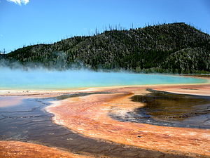
- 20 미드웨이 간헐천 분지. 이 간헐천 분지는 파이어홀 강이 내려다보이는 언덕에 있습니다. 이 지역의 다른 간헐천 분지보다 크기가 작기 때문에 열 특성에서 나온 유출수가 강으로 흘러들어가 김이 나는 다채로운 흔적을 남깁니다. 특히 Excelsior Geyser는 분당 4,000 US 갤런(15,000리터) 이상의 물이 Firehole 강으로 지속적으로 배출되는 200피트 × 300피트(60m × 90m)의 갈라진 분화구를 보여줍니다. 이 간헐천은 한때 너무 격렬하게 분출되어 실제로 자체적으로 폭발했을 수 있으며 그 이후로는 분출이 발생하지 않았습니다. 또한 이 놀라운 분지에는 옐로스톤에서 가장 큰 온천인 아름다운 색상의 Grand Prismatic Spring이 있습니다. 이 기능은 직경이 110m(370피트)이고 깊이가 50m(160피트)입니다. Fairy Falls 트레일 헤드는 샘 뒤 언덕에 있는 전망대에 접근할 수 있게 해주어 전체 분지를 높은 곳에서 볼 수 있게 해줍니다.
- 21 론스타 간헐천 분지. 이 오지 간헐천 분지는 올드 페이스풀 남쪽의 트레일 헤드에서 지금은 폐쇄된 오래된 도로를 따라 8.0km의 왕복 하이킹으로 쉽게 도달할 수 있습니다. Lone Star Geyser는 약 3시간마다 분출합니다. 간헐천 근처의 캐시에 간헐천 시간과 분출 유형을 관찰할 수 있는 일지가 있습니다. 자전거는 Lone Star에 가는 길을 최대한 만들 수 있습니다.
- 22 쇼쇼니 간헐천 분지. 쇼쇼니 간헐천 분지(Shoshone Geyser Basin)는 그랜트 패스(Grant's Pass)의 콘티넨탈 디바이드(Continental Divide)를 가로지르는 왕복 17마일(27km) 하이킹으로 도달할 수 있습니다. 이 유역에는 산책로가 없으므로 통과할 때 각별한 주의가 필요합니다. 유역의 산책로를 사용해야 합니다. 이와 같은 원격 열 영역은 존중, 지식 및 주의를 가지고 접근해야 합니다. 오지 분지에 들어갈 때 개인 안전과 자원 보호를 강조해야 합니다.
- 23 파이어홀 리버. 강의 이름은 초기 덫 사냥꾼들이 이 지역을 목격한 증기(불로 인한 연기라고 생각함)에서 따온 것입니다. 산 계곡에 대한 그들의 용어는 "구멍"이었고 지정이 태어났습니다. Firehole River는 도전적인 플라이 낚시로 세계적으로 유명한 명성을 자랑합니다. 브라운송어, 레인보우송어, 브룩송어는 낚시꾼에게 이 개울의 경계 대상입니다.
- 24 케플러 캐스케이드. 이 지역에서 가장 쉽게 접근할 수 있는 폭포입니다. Old Faithful 바로 남쪽에 표시된 철수 지점과 차에서 조금만 걸어가면 방문자가 이 125피트(38m) 폭포를 쉽게 볼 수 있습니다.
- 25 나팔꽃 수영장. "나팔꽃"(콘볼루투스), 풀과 유사합니다. 수영장의 색은 물에 서식하는 박테리아 때문입니다. 수영장은 거의 폭발하지 않습니다. 최근 관광객들이 구덩이에 물건을 던지는 바람에 막힘으로 인해 색이 변했습니다.
이 지역의 역사 및 교육 명소는 다음과 같습니다.
- 26 올드 페이스풀 인. 1903-04년 겨울에 지어진 Old Faithful Inn은 미국에 남아 있는 몇 안 되는 통나무 호텔 중 하나입니다. 양식화 된 디자인과 훌륭한 장인 정신으로 소박한 건축의 걸작입니다. 미국 건축, 특히 공원 건축에 미치는 영향은 측량할 수 없었습니다. 건물은 길이가 거의 700피트(210m)이고 높이가 7층에 달하는 거대한 비율의 소박한 통나무와 나무 프레임 구조입니다. 호텔 로비는 65피트(20m) 천장, 거대한 유문암 벽난로, 뒤틀린 롯지폴 소나무로 만든 난간을 갖추고 있습니다. 방문객은 로비 한가운데에 서서 노출된 구조물을 올려다보거나 꼬불꼬불한 통나무 계단을 올라 발코니 중 하나로 올라가 위, 아래 또는 건너편을 볼 수 있습니다. 1915년과 1927년에 호텔에 날개가 추가되었으며 현재 이 국립사적지에는 327개의 객실이 있습니다.
- 27 로워 해밀턴 스토어. 1897년에 지어진 이 건물은 여전히 사용 중인 Old Faithful 지역에서 가장 오래된 건축물입니다. "옹이가 있는 소나무" 현관은 방문객들에게 인기 있는 휴식처로 간헐천의 멋진 전망을 제공합니다. (Old Faithful에서 가장 오래된 건물은 F. Jay Haynes를 위해 1897년에 사진 스튜디오로 지어졌습니다. 이전에는 Beehive Geyser에서 남서쪽으로 700피트(210m), Old Faithful에서 북서쪽으로 약 350피트(110m) 떨어져 있었습니다. 충실한 여관, 그러나 지금은 횡단보도 근처의 그랜드 루프 로드와 소방차 교차로 근처에 서 있습니다.)
매디슨
매디슨은 올드 페이스풀과 노리스 간헐천 분지의 중간에 있으며 다양한 열 기능을 제공합니다.
- 28 아티스트 페인트팟. Artists Paintpots는 Norris Junction 바로 남쪽에 있는 작지만 사랑스러운 열 지역입니다. 1.6km 길이의 왕복 트레일은 다채로운 온천, 2개의 큰 진흙 항아리, 1988년에 불에 탄 삼림 구역으로 방문객을 안내합니다. 이 지역에 인접한 3개의 다른 오프 트레일, 오지 열 지역: Sylvan Springs , 기번 힐 간헐천 분지 및 간헐천 크릭 열 지역. 이 지역은 깨지기 쉽고 위험하며 접근하기 어렵습니다. 지식이 풍부한 직원 없이 여행하는 것은 권장되지 않습니다.
- 29 긴팔 폭포. 이 84피트(26m) 폭포는 옐로스톤 칼데라 가장자리의 잔해 위로 굴러떨어지며 공원 도로의 풀오버에서 쉽게 접근할 수 있습니다. 폭포에서 길 건너편에 있는 암벽이 칼데라의 안쪽 가장자리이다.
- 30 모뉴먼트 간헐천 분지. 이 작고 거의 휴면 상태인 분지는 매우 가파른 1마일(1.6km) 트레일의 꼭대기에 있습니다. 이 지역의 하이라이트는 훨씬 더 활동적인 시간의 잔재인 보온병 모양의 간헐천 콘, 여러 흥미로운 석회화 구조 및 멋진 전망을 포함합니다.
- 31 매디슨 강. 매디슨 강은 기번 강과 파이어홀 강의 교차점에서 형성되므로 매디슨 정션이 형성됩니다. 매디슨은 몬태나 주 쓰리 포크스에서 제퍼슨 강과 갤러틴 강과 합류하여 미주리 강을 형성합니다. 매디슨(Madison)은 갈색 송어와 무지개 송어와 산 화이트피쉬가 건강하게 서식하는 블루 리본 플라이 낚시 스트림입니다. 강이 만든 협곡은 양쪽이 나무로 덮인 가파른 암벽으로 이루어져 있습니다.
- 32 테라스 스프링스. Madison Junction 바로 북쪽에 있는 작은 열 지역. 이 지역은 방문객에게 온천의 짧은 산책로를 제공합니다.
- 33 파이어홀 캐년 드라이브 및 파이어홀 폭포. 측면 도로인 파이어홀 캐년 드라이브(Firehole Canyon Drive)는 매디슨 정션에서 파이어홀 강 상류를 따라 파이어홀 폭포 바로 위까지 이어집니다. 드라이브는 관광객을 800피트(240m) 두께의 용암 흐름을 지나게 합니다. Firehole Falls는 40피트(12m) 폭포입니다. 이곳의 무인 수영 구역은 가장 더운 여름 시즌에 매우 인기가 있습니다. 절벽 다이빙은 불법입니다.
- 34 국립공원산. 산은 Madison Junction 지역을 둘러싸고 있는 용암류의 일부입니다. 1870년 이 장소 근처에서 워시번-랭포드-도안 원정대가 캠핑을 하고 탐험하고 있던 지역의 미래에 대해 논의했다고 합니다. 전설에 따르면 이곳에서 국립 공원에 대한 아이디어가 논의되었지만 캠프 파이어 대화가 있었다는 증거는 없으며 국립 공원에 대한 아이디어가 논의되었다는 증거도 확실히 없습니다.
노리스

South of Mammoth, the Norris area is a home to a vast array of thermal features, including Steamboat Geyser, the world's largest. The area was named after Philetus W. Norris, the second superintendent of Yellowstone, who provided the first detailed information about the thermal features.
Thermal features and natural attractions in this area include:
- 35 Norris Geyser Basin. Norris Geyser Basin is the hottest, oldest, and most dynamic of Yellowstone's thermal areas. The highest temperature yet recorded in any geothermal area in Yellowstone was measured in a scientific drill hole at Norris: 459 °F (237 °C) just 1,087 ft (331 m) below the surface, and there are very few thermal features at Norris under the boiling point (199 °F or 93 °C at this elevation). Norris shows evidence of having had thermal features for at least 115,000 years. The features in the basin change daily, with frequent disturbances from seismic activity and water fluctuations. Steamboat Geyser, the tallest geyser in the world (300 to 400 feet or 90 to 120 metres) and Echinus Geyser (pH 3.5 or so) are the most popular features. The basin consists of three areas: Porcelain Basin, Back Basin, and One Hundred Springs Plain. Porcelain Basin is barren of trees and provides a sensory experience in sound, color, and smell; a 3/4-mile (1.2 km) dirt and boardwalk trail accesses this area. Back Basin is more heavily wooded with features scattered throughout the area; a 1.5-mile (2.4 km) trail of boardwalk and dirt encircles this part of the basin. One Hundred Springs Plain is an off-trail section of the Norris Geyser Basin that is very acidic, hollow, and dangerous. Travel is discouraged without the guidance of knowledgeable staff members.
- 36 활활 타오르는 산. Next to the park road just north of Norris on the Norris-Mammoth section of the Grand Loop Road, Roaring Mountain is a large, acidic thermal area (solfatara) that contains many steam vents (fumaroles) which make noises ranging from a nearly inaudible whisper to a roar that can be heard miles away. In the late 1800s and early 1900s, the number, size, and power of the fumaroles was much greater than today.
- 37 Gibbon River. The Gibbon River flows from Wolf Lake through the Norris area and meets the Firehole River at Madison Junction to form the Madison River. Both cold and hot springs are responsible for the majority of the Gibbon's flow. Brook trout, brown trout, grayling, and rainbow trout find the Gibbon to their liking. The Gibbon River is fly-fishing only below Gibbon Falls.
- 38 Virginia Cascades. A three-mile (4.8 km) section of the old road takes visitors past 60-foot (18 m) high Virginia Cascades. This cascading waterfall is formed by the very small (at that point) Gibbon River.
- Norris-Canyon Blowdown. This is a 22-mile (35 km) swath of lodgepole pine blown down by wind-shear action in 1984. It was then burned during the North Fork fire in 1988. This is the site where a famous news anchor said, "Tonight, this is all that's left of Yellowstone." A wayside exhibit there tells the story.
Historical and educational attractions in this area include:
- 39 The Norris Soldier Station. The Norris Soldier Station (Museum of the National Park Ranger) was an outlying station for soldiers to patrol and watch over Norris Geyser Basin. It was among the longest occupied stations in the park. A prior structure was built in 1886, replaced after fire in 1897, and modified in 1908. After the Army years, the building was used as a Ranger Station and residence until the 1959 earthquake caused structural damage. The building was restored in 1991.
- 40 The Norris Geyser Basin Museum. The Norris Geyser Basin Museum is one of the park's original trailside museums built in 1929-30. It has always been a museum. It is an outstanding example of a stone-and-log architecture.
거대한

Mammoth is home to the park headquarters and the impressive calcite terraces of Mammoth Hot Springs. This area has numerous services and is a surprisingly good place to see elk grazing on the manicured lawns surrounding the park administrative buildings.
Thermal features and natural attractions in this area include:
- 41 Mammoth Hot Springs. These mammoth rock formations are the main attraction of the Mammoth District and are accessible via boardwalk. These features are quite different from thermal areas elsewhere in the park as travertine formations grow much more rapidly than sinter formations due to the softer nature of limestone. As hot water rises through limestone, large quantities of rock are dissolved by the hot water, and a white chalky mineral is deposited on the surface. Formations here change rapidly, and while a favorite spring may appear to have "died," it is important to realize that the location of springs and the rate of flow changes daily, that "on-again-off-again" is the rule, and that the overall volume of water discharged by all of the springs fluctuates little.
- 42 The Gardner River and Gardner River Canyon. The North Entrance Road from Gardiner, Montana, to Mammoth Hot Springs, Wyoming, runs along the Gardner River. The road winds into the park, up the canyon, past crumbling walls of sandstone and ancient mudflows. The vegetation is much thicker in the canyon than on the open prairie down below, the common trees being Rocky Mountain juniper, cottonwood, and Douglas-fir. Low-growing willows also crowd the river's edge in the flatter, flood-prone sections of the canyon. Watch for wildlife in season: eagles, osprey, dippers, and kingfishers along the river and bighorn sheep in the steeper parts of the canyon.
- 43 45th Parallel Bridge and Boiling River. A sign north of where the road crosses the Gardner River marks the 45일 parallel of latitude. 표지판에서 조금 남쪽으로 가면 도로 동쪽에 있는 주차장이 공원에서 몇 안 되는 자연 가열된 물에 몸을 담글 수 있는 곳 중 하나인 "끓는 강"에서 해수욕객들이 이용하는 곳입니다. Bathers must walk upstream about a half mile (800 m) from the parking area to the place where the footpath reaches the river. 이 지점은 특히 추운 날씨에 큰 증기 구름으로 표시됩니다. 여기에서 Mammoth Terraces의 뜨거운 물 유출수는 Gardner 강으로 들어갑니다. 뜨거운 물과 차가운 물이 강 가장자리를 따라 수영장에서 섞입니다. 목욕은 낮 시간에만 강에서 허용됩니다. 수영복은 필수이며 주류는 허용되지 않습니다. 끓는 강은 위험한 높은 물로 인해 봄철에 닫히고 종종 한여름까지 다시 열리지 않습니다. 그것은 매우 혼잡 한 경향이 있으므로 성수기에는 아침 일찍 방문하십시오.
- 44 산. Everts. 산. Everts was named for explorer Truman Everts of the 1870 Washburn Expedition who became separated from his camping buddies, lost his glasses, lost his horse, and spent the next 37 days starving and freezing and hallucinating as he made his way through the un-tracked and inhospitable wilderness. Upon rescue, he was, according to his rescuers, within but a few hours of death. Everts never made it quite as far as Mt. Everts. He was found near the "Cut" on the Blacktail Plateau Drive and was mistaken for a black bear and nearly shot. His story, which he later published in Scribner의 월간 잡지, remains one of Yellowstone's best known, lost-in-the-wilderness stories. It has also been published in book form, edited by Yellowstone's archivist Lee Whittlesey under the name Lost in the Yellowstone. 산. Everts is made up of distinctly layered sandstones and shales--sedimentary rocks deposited when this area was covered by a shallow inland sea, 70 to 140 million years ago.
- 45 분젠봉. Bunsen Peak and the "Bunsen burner" were both named for the German physicist, Robert Wilhelm Bunsen. He was involved in pioneering research about geysers, and a "Bunsen burner" has a resemblance to a geyser. His theory on geysers was published in the 1800s, and it is still believed to be accurate. Bunsen Peak is 8,564-foot-high (2,610 m) and may be climbed via a trail that starts at the Golden Gate. Another trail, the old Bunsen Peak road, skirts around the flank of the peak from the YCC camp to the Golden Gate. This old road may be used by hikers, mountain-bikers, and skiers in winter. The peak overlooks the old Ft. Yellowstone area and it is only a gradual climb. Bring water and snacks (and bear bells if you think they'll work).
Historical and educational attractions in this area include:
- 46 Fort Yellowstone. All of the red-roofed, many-chimneyed buildings in the Mammoth area are part of historic Fort Yellowstone. Beginning in 1886, after 14 years of poor civilian management of the park, the Cavalry was called upon to manage the park's resources and visitors. Because the Cavalry only expected to be here a short while, they built a temporary post near the base of the Terraces called Camp Sheridan. After five cold, harsh winters, they realized that their stay in the park was going to be longer than expected, so they built Fort Yellowstone, a permanent post. In 1891, the first building to be constructed was the guard house because it directly coincided with the Cavalry's mission - protection and management. By 1916, the National Park Service was established, and the Cavalry gave control of Yellowstone back to the civilians. Since that time, historic Fort Yellowstone has been Yellowstone's headquarters.
- 47 루즈벨트 아치. The first major entrance for Yellowstone was at the north boundary. Robert Reamer, a famous architect in Yellowstone, designed the immense stone arch for coaches to travel through on their way into the park. At the time of the arch's construction, President Theodore Roosevelt was visiting the park. He consequently placed the cornerstone for the arch, which then took his name. The top of the Roosevelt Arch is inscribed with "For the benefit and enjoyment of the people," which is from the Organic Act of 1916.
- Kite Hill Cemetery. Dating to the 1880s, this cemetery contains graves of early settlers and employees.
- 48 Yellowstone Archives, Heritage and Research Center (go out through the North Entrance ( the Roosevelt Arch), bear left as you enter Gardiner, and go past the local high school (on the right); the road will re-enter the Park boundaries near the Center). Often overlooked because it's not well-advertised to Park Visitors, the Archives hold records and materials that are part of the National Archives, but in this case the location is managed by NPS. The Archives are generally open to the public May through September, but advance appointments are 필수 (mainly due to staffing constraints). In the Archives, you can find original photographs, journals and maps used by the original European expeditions to the area, along with more than a century of records, logs, photos and other materials starting from the Park's earliest days. Only a tiny fraction of these materials are represented in the various interpretive locations around the Park. The only danger to you here is time; it's easy to get lost in the history.
Tower-Roosevelt
The Tower area is one of the park's more rugged regions and is a good place for spotting wildlife. The Lamar Valley, east of Tower, is home to one of the park's more accessible wolf packs as well as elk, bighorn, and other large animals.
Thermal features and natural attractions in this area include:
- 49 Petrified Tree. The Petrified Tree, near the Lost Lake trail head, is an excellent example of an ancient redwood, similar to many found on Specimen Ridge, that is easily accessible to park visitors.
- 50 표본 능선. Along the Northeast Entrance Road east of Tower Junction, this area contains the largest concentration of petrified trees in the world. There are also excellent samples of petrified leaf impressions, conifer needles, and microscopic pollen from numerous species no longer growing in the park.
- 51 Tower Fall. This 132-foot-tall (40 m) waterfall is easily accessible from the main park road and is framed by eroded volcanic pinnacles.
- 52 Calcite Springs. This grouping of thermal springs along the Yellowstone River signals the downstream end of the Grand Canyon of the Yellowstone. The steep, columnar basalt cliffs on the opposite side of the river from the overlook are remnants of an ancient lava flow, providing a window into the past volcanic forces that shaped much of the Yellowstone landscape. The gorge and cliffs provide habitat for numerous wildlife species including bighorn sheep, red-tailed hawks, and osprey.
Historical and educational attractions in this area include:
- 53 The Buffalo Ranch. The Lamar Buffalo Ranch was built in the early part of the century in an effort to increase the herd size of the few remaining bison in Yellowstone, preventing the feared extinction of the species. Buffalo ranching operations continued at Lamar until the 1950s. The valley was irrigated for hay pastures, and corrals and fencing were scattered throughout the area. Four remaining buildings from the original ranch compound are contained within the Lamar Buffalo Ranch Historic District (two residences, the bunkhouse, and the barn) and are on the National Register of Historic Places. Visitors can drive by to view the historic buffalo ranch, however, there are no facilities open to the general public at this location.
- 54 The Tower Ranger Station & Roosevelt National Historic District. The Tower Ranger Station, though not on the National Register of Historic Places, is a remodeled reconstruction of the second Tower Soldier Station, which was built in 1907. The Roosevelt Lodge was constructed in 1920 and has been determined eligible for the National Register of Historic Places. The Roosevelt National Historic District also includes the Roosevelt cabins.
- 55 The Northeast Entrance Ranger Station. The Northeast Entrance Ranger Station was constructed in 1934-35 and is a National Historic Landmark. Its rustic log construction is characteristic of "parkitecture" common in the national parks of the west during that period.
Canyon

The Canyon village is named after the Grand Canyon of the Yellowstone and offers access to this impressive natural landscape. Recreational opportunities include hiking and wildlife viewing - the Hayden Valley area is probably the best place in the park for seeing bison.
Thermal features and natural attractions in this area include:
- 56 The Grand Canyon of the Yellowstone. The Grand Canyon of the Yellowstone is the primary geologic feature in the Canyon District. It is roughly 20 miles (32 km) long, measured from the Upper Falls to the Tower Fall area. Depth is 800 to 1,200 feet (240 to 370 m); width is 1,500 to 1,400 feet (460 to 430 m). The present canyon is no more than 10,000 to 14,000 years old, although there has probably been a canyon in this location for a much longer period. Chemical processes over time have left stripes and patches of different colors in the rock of this canyon. Trails lead along the north and south rims of the canyon, but while traveling the entire trail in one day is possible, it makes for a long and tiring day. Best to make it two shorter (~3 hour) day hikes. If you're a photo buff, plan your walks so the sun illuminates the opposite side for great pictures.
- 57 The Upper and Lower Falls of the Yellowstone. The Upper Falls is 109-foot-high (33 m) high and can be seen from the Brink of the Upper Falls Trail and from Uncle Tom's Trail. The Lower Falls is 308-foot-high (94 m) and can be seen from Lookout Point, Red Rock Point, Artist Point, Brink of the Lower Falls Trail, and from various points on the South Rim Trail. The Lower Falls is often described as being more than twice the size of Niagara, although this only refers to its height and not the volume of water flowing over it. A third falls can be found in the canyon between the Upper and Lower falls. Crystal Falls is the outfall of Cascade Creek into the canyon. It can be seen from the South Rim Trail just east of the Uncle Tom's area.
- 58 Hayden Valley. Hayden Valley is one of the best places in the park to view a wide variety of wildlife. It is an excellent place to look for grizzly bears, particularly in the spring and early summer when they may be preying upon newborn bison and elk calves. Large herds of bison may be viewed in the spring, early summer, and during the fall rut, which usually begins late July to early August. Coyotes can almost always be seen in the valley. Bird life is abundant in and along the river. A variety of shore birds may be seen in the mud flats at Alum Creek. A pair of sandhill cranes usually nests at the south end of the valley. Ducks, geese, and American white pelicans cruise the river. The valley is also an excellent place to look for bald eagles and northern harriers.
- 59 산. 워시번. 산. Washburn is the main peak in the Washburn Range, rising 10,243 ft (3,122 m) above the west side of the canyon. It is the remnant of volcanic activity that took place long before the formation of the present canyon. 산. Washburn was named for Gen. Henry Dana Washburn, leader of the 1870 Washburn-Langford-Doane Expedition. One of the best places in the park for spotting bighorn sheep and also a great spot for wildflowers, a trail leads up the mountain to a lookout tower near the 10,243-foot (3,122 m) summit. The altitude may affect some hikers, so it is best to be acclimatized to the higher elevation before attempting this hike. In addition, bring extra layers, even in the summer, since the top can be windy and cold.
Historical and educational attractions in this area include:
- 60 Canyon Village. The Canyon Village complex is part of the Mission 66 project in the park. The Visitor Center was completed in 1957, and the new lodge was open for business in the same year. Though some people consider the development representative of the architecture of the time, none of the present buildings in the complex can be considered historic. There are, however, still remnants of the old hotel, lodge, and related facilities.
하다

Many visitors believe they can visit all 2.2 million acres or 8.9 thousand km2 of Yellowstone in 1-2 days - all the while staying within sight of their car or tour bus. To truly appreciate this vast park, get off the park roads and paved tourist paths.
Park programs
- Car Free Week. Yellowstone opens its roads to bicyclists and hikers one week before car traffic resumes each spring (usually in April). This week is a rare opportunity to see Yellowstone's sights and wildlife without the crowds and traffic. Several West Yellowstone businesses rent bikes.
- Ranger-led programs. Ranger-led programs are offered year-round and provide an opportunity to visit a portion of the park in a small-group setting with a ranger who will provide information about the sights along the way. Most ranger programs involve a short hike.
- Junior Ranger Program. The Junior Ranger Program provides an opportunity for children 5 - 12 to earn a Junior Ranger patch. Ages 5-7 can earn the Wolf patch, and Ages 8-12 can earn the Bear patch. In order to get a patch, a 12-page activity booklet needs to be answered correctly and checked by a ranger. An activity booklet costs $3.
- Young Scientist. Students ages 5 and up can learn about Yellowstone's geothermal features. Students are given scientist toolkit, including an infrared thermometer, stop watch, magnifying glass and other gear. Once you've finished it, you have a choice of a patch or key chain.
활동
- 야생동물 관찰. There is a great variety of wildlife to view within the park limits. Birds (osprey, bald eagles, and many, many other species,) bison, big cats, deer, wolves, coyotes, foxes, bears, big-horn sheep, elk, and other animals can all be seen within the park in a short time. The more time that you spend in the park, the more wildlife you will see. Some animals, such as wolves, bears, and big-horn sheep, are generally not viewable from the park roads. Habitat preferences and seasonal cycles of movement determine, in a general sense, where a particular animal may be at a particular time. Early morning and evening hours are when animals tend to be feeding and thus are more easily seen. Wild animals, especially females with young, are unpredictable and dangerous. Keep a safe distance from all wildlife. Each year a number of park visitors are injured by wildlife when approaching too closely. Approaching on foot within 100 yards (91 m) of bears or wolves or within 25 yards (23 m) of other wildlife is extremely dangerous and strictly prohibited. Please use roadside pullouts when viewing wildlife. The spaces within the park are grand, so make sure to bring binoculars and/or a spotting scope to view animals safely and to avoid disturbing them. By being sensitive to its needs, you will see more of an animal's natural behavior and activity. If you cause an animal to move, you are too close! It is illegal to willfully remain near or approach wildlife, including birds, within ANY distance that disturbs or displaces the animal.
- 승마. Xanterra Parks & Resorts offers horse rides of one and two hours in length which are available at Mammoth, Tower-Roosevelt, and Canyon. Advance reservations are recommended. They also offer horseback or wagon rides which take visitors to a cookout site for a steak dinner. Advance reservations are required; call 1 307 344-7311 or 1-866-439-7375. TDD service (Telecommunications Device for the Deaf) is available at 307-344-5395. Online reservations are not available at this time. Guided stock trips into the backcountry (horse or llama) may be arranged with one of the stock outfitters licensed to operate in Yellowstone. Private stock can be brought into the park. Overnight stock use is not permitted prior to July 1, due to range readiness and/or wet trail conditions. Horses are not allowed in frontcountry campgrounds, but are permitted in certain backcountry campsites.
- 황야 배낭여행. Yellowstone has a designated backcountry campsite system, and a Backcountry Use Permit is required for all overnight stays. Each designated campsite has a maximum limit for the number of people and stock allowed per night. The maximum stay per campsite varies from 1 to 3 nights per trip. Campfires are permitted only in established fire pits. Wood fires are not allowed in some backcountry campsites. A food storage pole is provided at most designated campsites so that food and attractants may be secured from bears. 참조 오지 section below for additional details.
- 사진술. Yellowstone holds unprecedented photo opportunities with natural environments, beautiful hydrothermal features, and animals to be found throughout the park. The colors of the hot springs range from bland white (for the very, very hot) to yellows and blues, greens and oranges. Some of the features are very large, and the challenge can be finding a way to get them in the frame. Be creative! There have been a lot of pictures taken in Yellowstone, and there are a lot more still waiting to be taken.
- 어업. Permits are required for fishing, and not all areas are open to fishing; check with rangers. Native species include arctic grayling, Westslope cutthroat trout and Yellowstone cutthroat trout. Non-native species include brook trout, brown trout, lake trout and rainbow trout. 을 체크 해봐 park's fishing guidelines for the latest rules and regulations.
- 수영. Swimming is allowed (but not encouraged) at the Firehole Cascades swimming area, a section of the Firehole River that is warmed by hot springs. This area, accessible via the Firehole Canyon Drive, has a toilet but no lifeguard and not much parking. Swimming is also possible in the Boiling River near Mammoth. Swimming in Yellowstone Lake is permitted but not recommended due to temperatures which seldom exceed 66 °F (19 °C).
- 주유. A permit is required for all vessels (motorized and non-motorized including float tubes) and must be obtained in person at any of the following locations: South Entrance, Lewis Lake Campground, Grant Village Backcountry Office, and Bridge Bay Ranger Station. Non-motorized boating permits are available at West Entrance, Northeast Entrance, Mammoth Backcountry Office, Old Faithful Backcountry Office, Canyon Backcountry Office, Bechler Ranger Station, West Contact Station, West Yellowstone Chamber of Commerce and locations where motorized permits are sold. The fee is $20 (annual) or $10 (7 day) for motorized vessels and $10 (annual) or $5 (7 day) for non-motorized vessels. A Coast Guard approved wearable personal flotation device is required for each person boating. Boat permits issued in Grand Teton National Park are honored in Yellowstone, but owners must register their vessel in Yellowstone and obtain a no-charge Yellowstone validation sticker from a permit issuing station. Jet skis, personal watercraft, airboats, submersibles, and similar vessels are prohibited in Yellowstone National Park. All vessels are prohibited on park rivers and streams except the channel between Lewis and Shoshone Lakes, where only hand-propelled vessels are permitted. Outboards and rowboats may be rented (first come, first served) from Xanterra Parks & Resorts at Bridge Bay Marina on Yellowstone Lake. Xanterra also provides guided fishing boats which may be reserved in advance by calling 1 307 344-7311 or 1-866-GEYSERLAND (439-7375).
- 산악 자전거. most trails in the park are closed to mountain bikes, however several gravel roads are open to BOTH bicycle and automotive traffic. The Old Gardiner Road and Blacktail Plateau Drive allow two-way bike traffic and one-way auto traffic. These roads are best suited for mountain bikes and usually closed to autos and offer anther way to experience the park.
등산
The Fires of 1988 The summer of 1988 quite literally transformed the park and the national park system, as thirty-six percent of Yellowstone was affected by a massive, months-long wildfire that consumed 793,880 acres (3,212.7 km2) and caused the park to be completely shut down on September 8. The enormous conflagration cost $120 million to fight and at one point seriously threatened both the Old Faithful Inn and the historic buildings in Mammoth. The blaze was so powerful that it actually jumped across a river canyon, and media reports at the time often gave the erroneous impression that the park had been completely destroyed. Since the fire, the park management plan has changed. A contributing factor to the severity of the 1988 fire was the buildup of fuel from years of fire suppression, so today natural wildfires are allowed to burn unless they are deemed a danger. Most importantly, the fires of 1988 demonstrated the importance of fire to the natural ecosystem in restoring soil nutrients, dispersing seeds of fire-resistant plants such as lodgepole pines, and creating grazing land for animals like elk and bison. |
There are a huge number of day hikes available in the park, and since many visitors travel only to the most popular geyser basins these trails can provide an opportunity to see the park in a more natural setting.
Bridge Bay, Fishing Bridge & Lake
- 1 내츄럴 브릿지 (3 mi or 4.8 km round-trip), starts at the Bridge Bay Marina parking lot near the campground entrance road. This easy trail leads to a natural bridge that is a 51-foot (16 m) cliff of rhyolite rock cut through by Bridge Creek. The hiking trail meanders through the forest for 0.25 miles (400 m). It then joins a service road and continues to the right (west) for 1 mile (1.6 km) to the Natural Bridge. The short but steep switchback trail to the top of the bridge starts in front of the interpretive exhibit. Above the natural bridge, the trail crosses the creek through a narrow ravine and then continues along the cliff before rejoining the road. This trail is closed from Autumn through early summer while bears feed on spawning trout in Bridge Creek.
- Pelican Creek (1.3 mi or 2.1 km round-trip), starts at the west end of Pelican Creek Bridge, 1 mile (1.6 km) east of Fishing Bridge Visitor Center. This easy trail is a short but diverse trail that travels through the forest to the lakeshore before looping back across the marsh along Pelican Creek to the trailhead. It is a scenic introduction to a variety of Yellowstone's habitats and is a good place for birding.
- Storm Point (2.3 mi or 3.7 km round-trip), Indian Pond pullout, 3 miles (4.8 km) east of Fishing Bridge Visitor Center. This easy trail begins in the open meadows overlooking Indian Pond and Yellowstone Lake. It passes alongside the pond before turning right (west) into the forest. The trail continues through the trees and out to scenic, wind-swept Storm Point. The rocky area near the point is home to a large colony of yellow-bellied marmots. Following the shoreline to the west, the trail eventually loops back through the lodgepole forest and returns to Indian Pond. The trail is often closed in late spring and early summer due to bear activity; inquire at the Fishing Bridge Visitor Center about trail closures before hiking.
- 엘리펀트 백 마운틴 (3.6 mi or 5.8 km round-trip), Pullout 1 mile (1.6 km) south of Fishing Bridge Junction. This moderately strenuous trail climbs 800 feet (240 m) in 1.5 miles (2.4 km) through the dense lodgepole forest. After 1 mile (1.6 km), the trail splits into a loop. The left fork is the shortest route to the top, though both join again at the overlook. The overlook provides a sweeping panoramic view of Yellowstone Lake and surrounding area.
- Howard Eaton (7 mi or 11 km round-trip), Parking lot on east side of the Fishing Bridge. This easy trail follows the Yellowstone River for a short distance before paralleling the service road. After leaving the road, the first 2 miles (3.2 km) meander through meadow, forest, and sage flats with frequent views of the river. The last mile (1.6 km) passes through a dense lodgepole pine forest before climbing gradually to an overview of LeHardys Rapids. Those wanting a longer hike can continue to the Artist Point Road at Canyon, 12 miles (19 km) away, but that portion of the trail is not well maintained, requires a full day, and a car shuttle. The trail is often closed due to bear activity; inquire at the Fishing Bridge Visitor Center before hiking.
- 2 Pelican Valley (6.8 mi or 10.9 km round-trip), Turn onto the gravel road across from Indian Pond, 3 miles (4.8 km) east of Fishing Bridge Visitor Center; park at end of road. This moderately easy travels through some of the best grizzly country in the lower 48 states—and also prime habitat for bison and other grassland animals. The trail heads north, crosses a few bridges through a meadow, then enters the forest. After it leaves the forest, it ascends a small hill to a nice overlook of the valley, with the creek below and the Absaroka Mountains to the east. From here, the trail turns slightly to the right (east) and passes through a small hydrothermal area. Stay on the trail through this fragile and hazardous area. Soon, the trail veers north (left), crosses a small creek, and climbs up a cutbank. This is a good place to rest and enjoy the nice views of Pelican Creek. One mile (1.6 km) farther, the trail reaches a washed-out bridge. Beyond here the trail continues into Yellowstone's vast backcountry. The dayhike stops here; return by the same route. Many restrictions apply to this trail because it is in prime grizzly bear habitat: the trail is closed until July 4th, is allowed for day-use only (9AM - 7PM), is recommended for groups of four or more hikers, and off-trail travel is prohibited on the first 2.5 miles (4.0 km). Observe all bear-related precautions; be alert, make noise at blind curves and hills along the trail, and carry bear spray.
- 눈사태 피크 (4 mi or 6.4 km round-trip), 19 mi (31 km) east of Fishing Bridge Junction (8 mi or 13 km west of East Entrance), across the road from pullout at west end of Eleanor Lake. This extremely strenuous, high-elevation trail is often snow-covered until July, so check at the Fishing Bridge Visitor Center for current trail conditions. Across the road from the parking area and to the right of the creek, the trail enters the forest and begins its steep ascent — 2,100 ft (640 m) in 2 mi (3.2 km). In just over a mile (1.6 km), it arrives at the base of the large bowl of Avalanche Peak, then continues to the left and switches back over large talus slopes to an open level area below the summit. Follow the established trail up to the narrow ridgeline and cross it with extreme caution. Those who make this arduous hike will be rewarded with stunning views of some of the park's tallest and most remote alpine peaks. Return by the same route. Grizzly bears frequent this area in the fall, seeking out whitebark pine nuts. Hiking this trail is not recommended in September and October. Be aware of lightning above treeline, and even on warm summer days bring rain gear, wool hats, and gloves. Burned trees may fall without warning.
West Thumb & Grant Village
- West Thumb Geyser Basin (0.4 mi or 640 m round-trip), West Thumb Geyser Basin parking area, 0.25 miles (400 m) north of West Thumb Junction. An easy boardwalk trail that is wheelchair accessible with assistance on slopes. The trail offers a stroll through a geyser basin of colorful hot springs and dormant lake shore geysers situated on the scenic shores of Yellowstone Lake.
- Lake Overlook (2 mi or 3.2 km loop), On right as you enter West Thumb Geyser Basin parking area. The trail is moderately strenuous with a 400-foot (120 m) elevation gain near overlook. Hike to a high mountain meadow for a commanding view of the West Thumb of Yellowstone Lake and the distant Absaroka Mountains. The loop trail ascends steeply, passing backcountry thermal features, then gradually descends through meadows & forest.
- Duck Lake (1 mi or 1.6 km round-trip), At the end of the West Thumb Geyser Basin parking area, on the right. A moderately strenuous trail that climbs a small hill for a view of Duck and Yellowstone lakes and the expanse of the 1988 fires that swept through this area. Trail descends to shore of Duck Lake.
- Shoshone Lake (via DeLacy Creek) (6 mi or 9.7 km round-trip), 8.8 miles (14.2 km) west of West Thumb Junction. An easy hike along a forest's edge and through open meadows to the shores of Yellowstone's largest backcountry lake. Look for sandhill cranes in meadows, moose near shore, and water birds on and near the lake. Beyond here the trail continues into Yellowstone's vast backcountry. The day hike stops here; return by the same route.
- Riddle Lake (alt=4.8 mi or 7.7 km round-trip), Approximately 3 miles (4.8 km) south of the Grant Village intersection, just south of the Continental Divide sign. An easy hike that crosses the Continental Divide and travels through small mountain meadows and forests to the shores of a picturesque little lake. Look for elk in the meadows and for birds near the lake. The trail is in a bear management area and is closed until July 15; after July 15, groups of four or more people are recommended but not required.
- Lewis River Channel / Dogshead Loop (7 or 11 miles (11.3 or 17.5 km) round-trip), Approximately 5 miles (8.0 km) south of the Grant Village intersection, just north of Lewis Lake on west side of road.. A moderately strenuous trail that gives you a feel for Yellowstone's backcountry. Hike through forest to the colorful waters of the Lewis River Channel. Look for eagles and ospreys fishing for trout in the shallow waters. Turn around here for the shorter trip or continue on a loop trail that takes you to Shoshone Lake and returns on the forested Dogshead Trail. Beyond here the trail continues into Yellowstone's vast backcountry. The dayhike stops here; return by the same route.
올드 페이스풀

- Observation Point (1 mile (1.6 km) or 1.4 miles (2.3 km) round-trip (does not include portion on Upper Geyser Basin boardwalks)), Walk counterclockwise around the Old Faithful boardwalk; turn right at the sign to Geyser Hill. Trailhead is on the right after the Firehole River bridge, approximately 0.3 miles (480 m) from the visitor center. This moderately-strenuous trail gains 160 feet (49 m) of elevation with switchbacks that lead up the hill 0.5 miles (800 m) to a commanding view of the Upper Geyser Basin. Return the same way or continue west to Solitary Geyser, which erupts frequently, then to the Geyser Hill boardwalk. The longer route is 1.4 miles (2.3 km).
- Mallard Lake (6.8 mi or 10.9 km round-trip), Southeast side of the Old Faithful Lodge cabins, near the Firehole River. Take the first right turn as you come into the Lodge area and continue down the road to the trailhead. This moderately strenuous trail crosses the Firehole River, passes Pipeline Hot Springs, and climbs rolling hills of partially-burned lodgepole pine and open, rocky areas to the lake. Return the same way. (Or return via the Mallard Creek trail, for a total of 12 miles or 19 km)
- Howard Eaton (5.8 mi or 9.3 km round-trip), Park near the Old Faithful Ranger Station, then follow the paved path across the Grand Loop Road. Turn left at the first intersection, turn left again, and follow orange trail markers to the beginning of the trail.. A moderately difficult trail that climbs a burned hill, continues through spruce-fir forest, then down to Lone Star Geyser. Return the same way.
- 론스타 (4.8 mi or 7.7 km round-trip), 3.55 miles (5.71 km) south of Old Faithful Junction, just beyond parking for Kepler Cascades.. An pleasant, easy, partially paved trail follows an old service road beside the Firehole River to the geyser. Cyclists must dismount at the end of the asphalt and walk the last few hundred feet. Lone Star erupts up to 45 feet (14 m) from a 12-foot (3.7 m) cone approximately every three hours.
- 나누기 (3.4 mi or 5.5 km round-trip), 6.8 miles (10.9 km) south of Old Faithful Junction, look for a pullout on the right. This moderately strenuous trail crosses Spring Creek and climbs 735 feet (224 m) through mixed conifer forest to the Continental Divide. You can see Shoshone Lake from halfway up the trail.
- Mystic Falls (2.5 mi or 4.0 km round-trip), At the back of the Biscuit Basin boardwalk, 2 miles (3.2 km) north of Old Faithful Junction. You can also begin 0.25 miles (400 m) south of Biscuit Basin; park in pullouts on either side of the road. A moderately strenuous trail that follows a lovely creek through mixed conifer forest to the 70-foot (21 m) falls, over which the Little Firehole River drops from the Madison Plateau. Turn around here or climb the switchbacks to an overlook of the Upper Geyser Basin, then loop back to the main trail. The trail passes through a bear management area and is closed until the Saturday of Memorial Day weekend.
- Mallard Creek (9.2 mi or 14.8 km round-trip), Approximately 3.8 miles (6.1 km) north of Old Faithful Junction, toward Madison; look for a trailhead sign and pullout on the right. A strenuous trail that was designed as a winter ski trail. The route follows hilly terrain through heavily burned forest up to Mallard Lake. Return the same way or, if you have arranged a car shuttle, follow the Mallard Lake Trail to the Old Faithful area.
- Fairy Falls, Short route: Park 1 mile (1.5 km) south of Midway Geyser Basin, cross the steel bridge and walk 1 mile (1.5 km) to the trailhead. Long route: park at the end of Fountain Flat Dr. and walk 1.75 miles (2.82 km) to the trailhead.. This easy trail travels through young forest 1.6 miles (2.6 km) to the 200-foot (61 m) falls. 폭포를 지나 0.65마일(1.05km)을 계속해서 습한 지역을 지나 작은 분출이 자주 발생하는 임페리얼 간헐천까지 갑니다. 트레일은 곰 관리 구역을 통과하며 현충일 주말 토요일까지 폐쇄됩니다.
- Sentinel Meadows 및 Queen's Laundry (왕복 4.8km 또는 Queen's Laundry로 이동하는 경우 6.4km), Old Faithful에서 북쪽으로 16km 떨어진 Fountain Flat Drive에서 좌회전하십시오. 도로 끝에 주차하고 파이어홀 강(Firehole River)을 가로지르는 인도교를 건너 트레일 헤드로 이동합니다.. 봄에는 매우 젖고 여름에는 버기가 있는 적당히 험난한 트레일입니다. 흔적은 Firehole 강을 따라 짧은 거리를 따라 초원으로 향합니다. 트레일 시작점에서 3.1km 떨어진 Queen's Laundry에서 거대한 온천 소굴과 불완전하고 오래된 목욕탕의 유적을 찾아보세요. 1881년에 시작된 공사는 공원 관리와 우선 순위가 변경됨에 따라 중단되었습니다. 온천에서 나오는 광물은 구조를 보존했는데, 이는 국립공원에서 공공 사용을 위해 정부가 건설한 최초의 건물이었습니다. Queen's Laundry는 국립 사적지입니다.
매디슨
- 퍼플 마운틴 (6마일 또는 9.7km 왕복), Madison-Norris 도로의 Madison Junction에서 북쪽으로 400m(0.25마일), 제한된 주차 공간. 이 적당히 어려운 트레일은 간헐적으로 불타버린 롯지폴 소나무 숲을 통해 460m(1,500피트)를 오르고 Firehole Valley와 낮은 Gibbon Valley의 멋진 전망으로 끝납니다. Madison Junction 지역의 일부 전망도 볼 수 있습니다.
- 할리퀸 호수 (왕복 1마일 또는 1.6km), 서쪽 입구 도로의 매디슨 캠프장에서 서쪽으로 1.5마일(2.4km). 이것은 모기와 물새(그러나 할리퀸 오리는 아님)에게 인기 있는 작고 습한 호수로 불타버린 롯지폴 소나무를 통과하는 완만한 오르막입니다. 잠시 길을 벗어나기에 좋은 빠른 하이킹.
- 투 리본 트레일 (왕복 1.5마일 또는 2.4km), 서쪽 입구에서 동쪽으로 약 5마일(8.0km), 표시가 있는 트레일 헤드가 없음, 큰 철수에서 보드워크 옆의 길가 전시물을 찾으세요.. 이것은 매디슨 강 옆에 있는 불에 탄 롯지폴 소나무와 세이지브러시 군락을 지나는 완전히 산책로입니다. 버팔로 왈로우뿐만 아니라 화재 복구 및 재성장의 좋은 예입니다. 트레일 헤드의 길가 전시물 외에는 설명 표지판이나 브로셔가 없습니다.
- 갈라틴 지역. Gallatin 지역에는 훌륭한 하이킹 기회가 많이 있습니다. 그러나 이들 대부분은 평균 일일 하이킹보다 길고 가파르다. 여기에는 Daily Creek, Sky Rim, Black Butte, Specimen Creek, Crescent Lake/High Lake, Sportsman Lake, Bighorn Pass 및 Fawn Pass가 포함됩니다. 자세한 내용은 방문자 센터나 옐로스톤 협회에서 제공하는 하이킹 트레일 가이드를 참조하십시오.
노리스

- 그리즐리 호수 (왕복 4마일 또는 6.4km), Mammoth-Norris 도로의 Beaver Lake에서 남쪽으로 1마일(1km). 이 적당히 험난한 길은 두 번 불에 탄 롯지폴 소나무 가판대(1976년과 1988년)와 멋진 초원을 지나갑니다. 호수는 길고 좁으며 나무가 무성합니다. 호수의 트레일 끝을 넘어서는 접근이 어려울 수 있습니다. 습지와 모기는 시즌 초반에 여행을 어렵게 만들 수 있습니다. 호수는 작은 개울 송어의 인구가 많기 때문에 낚시꾼들에게 인기가 있습니다. Grizzly Lake를 지나 계속하려면 통나무 가로수가 필요합니다.
- 솔파타라 크릭 (왕복 13마일 또는 21km), Norris Campground 및 Mammoth-Norris 도로의 Beaver Lake Picnic Area에서 남쪽으로 1.21km 떨어진 루프 C의 시작점. 한 번의 오르막과 내리막이 약 120m(400피트)에 걸쳐 있는 쉬운 길입니다. 이 트레일은 솔파타라 크릭(Solfatara Creek)을 따라 아이스 레이크 트레일(Ice Lake Trail)과의 교차점까지 짧은 거리에 있으며, 그 다음 대부분의 화이트록 스프링스(Whiterock Springs)로 가는 전력선과 평행을 이룹니다. 그것은 Lake of the Woods까지 짧은 거리를 오르고(길에서 약간 떨어져 있어서 찾기가 어렵습니다) Amphitheatre Springs와 Lemonade Creek을 지나갑니다(마시지 마십시오). 이들은 작지만 설명이 없는 롯지폴 소나무 숲의 꽤 열적인 지역입니다. 그런 다음 길은 계속해서 길을 만난다. 당신이 왔던 길을 제외하고는 캠프장으로 돌아가는 트레일 연결이 없습니다. 양쪽 끝에 주차하는 것이 바람직합니다. 이곳은 다른 등산객을 많이 보고 싶지 않은 사람들을 보내기에 좋은 곳이지만 곰 제한이 있을 수 있으므로 출발하기 전에 레인저에게 확인하십시오.
- 아이스 레이크 트레일(직행) (0.3마일 또는 0.48km), Norris-Canyon 도로에서 Norris 동쪽으로 5.6km. 장애인이 쉽게 접근할 수 있는 이 트레일은 울창한 롯지폴 소나무 숲에 자리 잡은 아름다운 작은 호수로 이어집니다. 일부 지역은 1988년에 심하게 불탔습니다. 등산객은 아이스 레이크에서 울프 레이크, 그레베 레이크, 캐스케이드 레이크까지 계속해서 캐년까지 갈 수 있습니다.
- 울프 레이크 컷오프 트레일 (6마일 또는 왕복 9.7km; Wolf Lake Trail과 합류점까지 1.6km, Wolf Lake까지 3km), Canyon-Norris Road의 Ice Lake Trailhead에서 동쪽으로 약 400m 떨어진 큰 풀아웃. 트레일에 정기적인 정비가 이루어지지 않아 트레일 헤드 표지판은 없지만 등산객이 트레일 헤드에서 길을 건너면 주황색 표시를 볼 수 있습니다.. 이 트레일은 개울 횡단과 몰락으로 인해 적당히 어렵습니다. 때때로 흔적을 찾기 어려울 수 있습니다. 경로는 최소 1마일(1km) 동안 기번 강을 따라 리틀 기번 폭포를 지나갑니다. 울창하고 부분적으로 불타버린 롯지폴 소나무 숲은 울프 호수로 가는 길의 주요 동반자입니다.
- 시그넷 레이크 트레일 (왕복 8마일 또는 13km), 캐년 분기점에서 서쪽으로 약 5.5마일(8.9km) 떨어진 Norris-Canyon 도로 남쪽의 철수. 이 쉬운 트레일은 간헐적으로 불타오르는 롯지폴 소나무 숲을 지나 작은 습지의 일시적인 연못을 지나 Cygnet Lakes(작고 늪지대)를 둘러싼 무성한 초원으로 이어집니다. 당일 이용만 가능! Cygnet Lakes 너머로 트레일이 유지되지 않습니다.
- 아티스트 페인트 냄비 (왕복 1마일 또는 1.6km), Norris-Madison 도로에서 Norris 남쪽으로 7.2km. 이 쉬운 트레일은 옐로스톤의 간과되었지만 멋진 짧은 하이킹 중 하나입니다. 산책로의 젖은 초원을 가로질러 구불구불한 트레일은 부분적으로 불타버린 롯지폴 소나무 숲으로 들어갑니다. 트레일 끝에 있는 짧은 루프 내의 온천 지역에는 이 지역에서 발견되는 가장 다채로운 온천과 작은 간헐천이 있습니다. 언덕 꼭대기에 있는 두 개의 진흙 항아리는 Fountain Paint Pots보다 더 가까운 접근을 허용합니다. 날리는 진흙 주의! 사람들에게 지역 전체에 걸쳐 트레일을 유지하도록 상기시킵니다. 트레일은 가파른 오르막/내리막 구간이 하나 있으며, 트레일은 쉽게 침식되어 비가 온 후에는 길을 잃을 수 있습니다.
- 모뉴먼트 간헐천 분지 (2마일 또는 3.2km), Norris-Madison 도로의 Norris Junction에서 남쪽으로 8.0km(8km), Gibbon River Bridge 바로 뒤. 이 길은 믿을 수 없을 정도로 쉬웠다가 어렵습니다. 그것은 긴팔 강을 따라 완만한 경사를 따라 구불구불한 다음 급격히 오르막으로 바뀌고 1/2마일(800m)에 500피트(150m)를 산 정상까지 올라갑니다! 기초는 침식 간헐암과 유문암 위에 있으며, 볼 베어링을 연상시킵니다. 간헐천 분지는 다양한 크기의 휴면 원뿔의 매우 흥미로운 컬렉션입니다. 하나는 보온병과 비슷합니다! 여기에서 대부분의 활동이 말랐습니다. 흥미진진한 열 활동을 찾는 등산객들은 실망할 것이지만 모험을 찾는 사람들은 찾을 수 있을 것입니다. 사람들에게 흔적을 남기도록 상기시키십시오!
거대한
- 비버 연못 루프 (왕복 5마일 또는 8.0km) (리버티 캡과 매머드 테라스 옆 석조 주택 사이). 이 적당히 힘든 트레일은 리버티 캡(Liberty Cap)과 매머드 테라스(Mammoth Terraces) 바로 북쪽에서 시작하여 클레마티스 협곡(Clematis Gulch) 위로 110m(350피트) 오르막으로 시작됩니다. Sepulcher Mountain Trail과의 교차점에서 오른쪽으로 가십시오. 그 후 얼마 지나지 않아 트레일은 평탄해지고 초원과 사시나무 덤불을 지나 일련의 비버 연못으로 이어집니다. 엘크, 노새 사슴, 대혼란, 큰사슴, 비버 댐 및 롯지, 가끔 비버, 물새를 찾으십시오. 곰을 조심하세요. 검은곰과 회색곰 모두 이 지역에서 먹이를 찾습니다. 연못을지나 트레일은 숲과 초원을지나 매머드로 돌아갑니다.
- 분젠봉 (왕복 4.2마일 또는 6.8km), 매머드에서 남쪽으로 8.0km 떨어진 매머드-노리스 로드(Mammoth–Norris Road), 글렌 크릭 트레일 헤드 건너편. 이 적당히 험난한 트레일은 숲과 초원을 지나 1,300피트(400m)를 올라 블랙테일 고원, 백조의 호수 평지, 갤러틴 산맥, 옐로스톤 강 계곡의 탁 트인 전망이 있는 분젠 피크(Bunsen Peak) 정상까지 올라갑니다. (매머드와 인근 지역 사회에 공급하는 통신 장비도 볼 수 있습니다.) 같은 경로로 돌아오세요.
- 오스프리 폭포 (왕복 8마일 또는 13km), 매머드에서 남쪽으로 8.0km 떨어진 매머드-노리스 로드(Mammoth–Norris Road), 글렌 크릭 트레일 헤드 건너편. Bunsen Peak Road(하이킹/자전거 전용)를 따라 초원과 불타버린 숲을 지나 Osprey Falls Trail(자전거 금지)까지 2.5마일(4.0km)의 험난한 트레일입니다. 700피트(210m)를 내려가 옐로스톤에서 가장 깊은 협곡 중 하나인 쉬피터 캐년(Sheepeater Canyon)으로 내려갑니다. 가드너 강(Gardner River)에 있는 오스프리 폭포(Osprey Falls)는 용암류 가장자리 위로 150피트(46m)를 떨어뜨립니다.
- 라바 크릭 (3.5마일 또는 5.6km 편도), Mammoth–Tower Roa의 Lava Creek 피크닉 장소 건너편. Lava Creek을 따라 Undine Falls(60피트/18m)를 지나 하류로 이어지는 적당히 험난한 트레일입니다. Lava Creek은 더 하류에서 Gardner 강과 만납니다. 트레일은 인도교를 통해 강을 건너 마지막 가파른 오르막으로 이어져 매머드 캠프장 근처에서 끝납니다.
- 레스큐 크릭 (8마일 또는 13km 편도), Mammoth-Tower Road에서 Mammoth 동쪽으로 11km, 북쪽 입구 역에서 남쪽으로 1마일(1.6km) 끝. Blacktail Deer Creek Trail을 따라 Blacktail Pond의 동쪽 끝을 지나 짧은 언덕 꼭대기까지 이어진 후 Rescue Creek Trail에서 왼쪽으로 방향을 틀게 되는 적당히 힘든 트레일입니다. 사시나무와 초원을 따라 점차 오르고, 숲을 지나 쑥갓 평지로 내려가면 가드너 강을 가로지르는 인도교로 이어집니다.
- 블랙테일 디어 크릭/옐로스톤 리버 (12마일 또는 19km 편도), Mammoth–Tower Road의 매머드에서 동쪽으로 11km. Blacktail Deer Creek을 따라 1,100피트(340m)를 내려가는 풀이 우거진 구릉과 더글러스 전나무 숲을 지나 옐로스톤 강까지 이어지는 적당히 힘든 트레일입니다. 강철 현수교를 타고 강을 건너 옐로스톤 리버 트레일(Yellowstone River Trail)에 합류하여 강을 따라 계속 내려가면 노울스 폭포(Knowles Falls)를 지나 MT의 가디너(Gardiner)에서 끝날 때까지 건조한 지형으로 들어갑니다. 가디너 근처에 매우 좁고 짧은 구간이 있어 젖으면 미끄럽습니다.
- 무덤 산 (왕복 11마일 또는 18km) (리버티 캡과 매머드 테라스 옆 석조 주택 사이). 이 험난한 트레일은 비버 폰즈 트레일을 따라 세펄처 마운틴 트레일 교차로까지 이어진 다음 숲과 초원을 지나 1,000m(3,400피트)를 올라 9,652피트(2,942m) 정상 회담에 도달합니다. 루프 트레일은 개방된 경사를 통해 산 반대편을 따라 계속 이어지며 스노우 패스 트레일의 교차점까지 이어지며 북쪽으로 매머드 테라스와 트레일 헤드까지 이어지는 하워드 이튼 트레일(Howard Eaton Trail)로 내려갑니다.
타워 루즈벨트
- 잃어버린 호수 (왕복 4마일 또는 6.4km), 루즈벨트 롯지 뒤. 로스트 레이크(Lost Lake), 물새, 젖은 초원, 쑥쑥 언덕 꼭대기, 야생화, 아마도 비버, 그리고 꽤 자주 흑곰의 전망을 제공하는 적당히 어려운 트레일입니다. 이 트레일은 Roosevelt Lodge 뒤에서 시작하여 벤치까지 300피트(91m) 올라갑니다. 여기에서 Roosevelt 말 트레일과 합류하여 서쪽으로 Lost Lake까지 계속됩니다. 로스트 레이크(Lost Lake)에서 오솔길은 언덕 주변의 등고선을 따라 Petrified Tree 주차장까지 이어지며 주차장을 건너 언덕을 계속 올라갑니다. 타워 레인저 역 뒤에서 순환하여 개울을 건너 롯지로 돌아옵니다. 주의: 말과 마주치면 트레일의 내리막길로 이동하여 말이 지나갈 때까지 가만히 있으십시오.
- 가넷 힐 (왕복 7.5마일 또는 12.1km), 북동쪽 입구 도로의 타워 정션에서 북쪽으로 약 50야드(45.7m). (타워 정션 주유소 동쪽 넓은 주차장에 주차하세요.). 비포장 마차 도로를 따라 약 1.5마일(2.4km)가량의 쿡아웃 대피소까지 이어지는 적당히 험난한 트레일입니다. 엘크 크릭을 따라 북쪽으로 계속 가다 거의 옐로스톤 강에 도달합니다. 여기에서 트레일이 나뉩니다. 서쪽 갈림길은 Hellroaring Trail과 합류하고 동쪽 갈림길은 Garnet Hill을 둘러싸고 다시 타워 쪽으로 계속 이어집니다. 도로 가까이에 있는 산책로는 북동쪽 입구 도로로 이어지는 말길과 합류합니다. 도로를 따라 약 400m 정도 걸어가면 주차장으로 돌아옵니다.
- 헬로링 (왕복 4마일 또는 6.4km), 타워 정션에서 서쪽으로 5.6km. Yellowstone River Suspension Bridge까지 가파른 내리막으로 시작하여 쑥쑥 고원을 지나 Hellroaring Creek까지 내려가는 험난한 트레일입니다. 옐로스톤 강과 헬로어링 크릭은 모두 인기 있는 낚시 지역입니다. 이 트레일은 여름 동안 덥고 건조할 수 있으므로 물을 가져오세요. 또한, 강 옆의 바위에 발을 디디고 있는지 확인하고 다른 오지 트레일이 이 트레일에서 분기되므로 트레일 표지판에 주의하십시오. 대체 루트는 Garnet Hill에서 시작하여 Hellroaring 트레일에서 서쪽으로 계속됩니다. Garnet Hill 트레일 헤드로 돌아갑니다(16km/10마일).
- 옐로스톤 리버 피크닉 지역 (왕복 3.7마일 또는 6.0km), Northeast Entrance Road의 Tower Junction에서 북동쪽으로 2.01km 떨어진 Yellowstone River Picnic 지역. 옐로스톤의 내로우즈(Narrows of the Yellowstone) 동쪽 가장자리까지 가파르게 오르다가 가장자리를 따라가는 적당히 어려운 트레일입니다. 협곡에 둥지를 틀고 있는 송골매와 물수리와 가장자리를 따라 큰뿔양을 찾아보세요. Overhanging Cliff 지역, Tower Fall의 타워(폭포는 보이지 않음), 현무암 기둥 및 역사적인 Bannock Ford를 보십시오. 트레일은 북동쪽으로 향합니다. 다음 트레일 교차로에서 좌회전하여 도로로 내려갑니다. (Specimen Ridge Trail은 험난하고 표시가 잘 안 된 북동쪽으로 계속 이어집니다.) 도로를 따라 서쪽으로 1.1km를 걸어 옐로스톤 강 피크닉 지역까지 가십시오.
- 슬러프 크릭 (첫 번째 초원: 3.2km, 두 번째 초원: 편도 7.2km), Slough Creek Campground로 향하는 흙길에서; 길이 왼쪽으로 향하는 곳, 금고 화장실 옆에 주차. 처음 1.5마일(2.4km)은 적당히 힘든 트레일입니다. 그럼 쉽게. 이 장거리 트레일은 옐로스톤 너머 Absaroka-Beartooth Wilderness로 향하는 역사적인 마차 트레일을 따릅니다. 가파른 오르막으로 시작하여 첫 번째 초원으로 내려갑니다. 여기서 멈추고 휴식을 취하거나 두 번째 초원으로 계속 가십시오. 곰과 무스를 조심하세요. 주의: 말과 마주치면 트레일의 내리막길로 이동하여 말이 지나갈 때까지 가만히 있으십시오.
- 산. 워시번 (Dunraven Pass에서, 5.0km(3.1마일); Chittenden Road에서, 편도 4.0km), 타워 정션에서 남쪽으로 14.0km 떨어진 Chittenden Road Parking Area; 타워-캐년 로드의 타워 정션에서 남쪽으로 21.9km 떨어진 던레이븐 패스 주차장. 북쪽 트레일 헤드에 더 많은 주차 공간이 있습니다. 자전거와 공원 차량도 이 경로를 사용합니다.. 430m(1,400피트)를 올라가는 험난한 트레일입니다. 어느 길이든 후지산을 오른다. 장엄한 전망과 함께 넓은 길에 워시번. 큰뿔양과 야생화를 찾아보세요. 깨지기 쉬운 고산 식물이 파괴되지 않도록 트레일을 계속 유지하십시오. 정상에서는 화재 감시기 아래에 있는 대피소 내부의 전망과 해설 전시를 감상할 수 있습니다. 이것은 고도가 높은 트레일입니다. 폭풍이 자주 발생합니다. 우비, 양모 모자 및 장갑을 가져 오십시오.
깊은 협곡

- 하워드 이튼 트레일(Cascade, Grebe, Wolf 및 Ice Lakes 및 Norris까지) (목적지에 따라 편도 4km 또는 19.3km), Norris–Canyon Road의 Canyon Junction 서쪽 0.25마일(400m). 이 적당히 쉬운 트레일은 오르막이 거의 없으며 등산객이 숲, 초원 및 습지를 통과하는 트레일에서 목적지를 선택할 수 있는 기회를 제공합니다. Cascade Lake(2.5마일/4.0km), Grebe Lake(4.25마일/6.84km), Wolf Lake(6.25마일/10.06km), Ice Lake(8.25마일/13.28km) 및 Norris Campground(12마일/19km). 트레일은 7월까지 물기가 많고 많은 벌레가 있어 젖고 진흙탕이 될 수 있습니다.
- 전망대 (왕복 11마일 또는 18km), Tower–Canyon Road의 Canyon Junction 북쪽으로 2.01km(1.25마일). 이 험난한 트레일은 옐로스톤 황야의 뛰어난 전망을 제공하는 높은 산봉우리로 가는 길에 4.8km(3마일)에 430m(1,400피트) 수직 상승이 있습니다. 트레일은 열린 초원을 지나 캐스케이드 호수로 이어집니다(유인물 뒷면에 설명). 호수 너머로 4.8km(3마일) 동안 430m(1,400피트)를 올라 화이트바크 소나무 숲을 통과합니다. 캐스케이드 호수를 지나면 물이 없습니다.
- 캐스케이드 레이크 (왕복 5마일 또는 8.0km), pullout Norris-Canyon Road 또는 Cascade Lake Trailhead의 Canyon Junction 서쪽 0.25마일(400m), Tower-Canyon Road의 Canyon Junction 북쪽 2.01km. 이 쉬운 산책을 통해 시간이 제한된 사람들은 야생화가 풍부하고 야생 동물을 자주 볼 수있는 열린 초원을 즐길 수 있습니다. 트레일은 7월까지 물기가 많고 벌레가 많아 진흙탕이 될 수 있습니다.
- 그레베 호수 (6마일 또는 9.7km 왕복), Norris–Canyon Road의 Canyon Junction에서 서쪽으로 5.6km(3.5마일). 이 적당히 쉬운 트레일은 초원과 숲을 통과하는 오래된 불길을 따라가기 때문에 수직 상승이 거의 없습니다. 그 중 일부는 1988년에 불탔습니다. 호수에서 하워드 이튼 트레일(Howard Eaton Trail)과 연결하거나 왔던 길로 돌아갈 수 있습니다.
- 세븐 마일 홀 (왕복 11마일 또는 18km), 인스피레이션 포인트로 가는 길에 있는 Glacial Boulder 철수. 협곡을 가로지르는 실버 코드 캐스케이드(Silver Cord Cascade)의 전망을 제공하는 처음 1.5마일(2.4km) 동안 협곡 가장자리를 따라 이어지는 험난한 트레일입니다. 또 다른 반마일(800m)에서 트레일은 워시번 스퍼 트레일과 합류합니다. 다시 3마일(4.8km) 후에 세븐 마일 홀(Seven Mile Hole)로 가는 트레일로 우회전하여 1.5마일(2.4km)에 1,000피트(300m) 이상 떨어집니다. 트레일이 휴면 온천과 활성 온천을 모두 통과하는 곳에서는 특히 주의하십시오.
- 산. 워시번 (Dunraven Pass에서 편도 5km, Chittenden Road에서 편도 4km), 캐년 정션에서 북쪽으로 7.2km 떨어진 던레이븐 패스(Dunraven Pass); Chittenden Road, Canyon Junction 북쪽으로 16.6km. 이 힘든 트레일은 430m(1,400피트) 상승합니다. 양쪽 트레일 헤드에서 시작하여 Mt. 장엄한 전망이 있는 넓은 트레일의 워시번. 큰뿔양(거리 유지)과 야생화를 찾아보세요. 깨지기 쉬운 고산 식물이 파괴되지 않도록 트레일을 계속 유지하십시오. 정상에서는 화재 감시기 아래에 있는 대피소 내부에서 전망과 해설 전시를 감상할 수 있습니다. 주의: 폭풍은 일반적입니다. 우비, 양모 모자 및 장갑을 가져 오십시오.
- 워시번 스퍼 트레일 (11-11.5 마일 또는 18-18.5km 편도, 산에 따라 다릅니다. 사용하는 워시번 트레일), Mt. 워시번. 4.0km(2.5마일)에 610m(2,000피트) 상승하는 험난한 트레일입니다. 워시번 산을 오른 후 산불 감시소의 동쪽에서 박차를 가하십시오. 트레일은 6.0km(3.7마일) 동안 거친 지형을 따라 매우 가파르게 내려와 워시번 핫 스프링스(Washburn Hot Springs)까지 이어집니다. 주의: 이 열수 지역의 트레일을 따라가십시오. 남쪽으로 계속 이동하여 세븐 마일 홀(Seven Mile Hole)로 가는 분기점을 지나 인스피레이션 포인트(Inspiration Point)로 가는 길에 있는 Glacial Boulder 풀아웃에서 끝납니다. 트레일은 매우 열악한 상태입니다.
구입
공원 내의 모든 주요 마을에서는 음식, 캠핑 용품 및 기념품을 판매하지만 이러한 상점은 모두 겨울철에 문을 닫습니다.
가솔린 및 자동차 서비스는 다음 위치에서 사용할 수 있습니다.
- 깊은 협곡. 4월말~11월초 오픈. 가솔린, 디젤 및 자동차 수리.
- 낚시대. 5월 중순~9월 하순 개장. 가솔린, 디젤, 프로판 및 자동차 수리.
- 그랜트 빌리지. 4월 중순~10월 중순 오픈. 가솔린, 디젤, 프로판 및 자동차 수리.
- 거대한. 5월 초순~10월 중순 오픈. 가솔린과 디젤.
- 올드 페이스풀(하위). 4월 중순 ~ 11월 초 오픈. 가솔린과 디젤.
- 올드 페이스풀(위). 5월 하순~9월 하순 영업. 가솔린 및 자동차 수리.
- 타워 정션. 6월초~9월초 오픈. 가솔린.
먹다

대부분의 마을에서는 식료품을 판매하고 스낵바를 제공할 수 있습니다. 다음 레스토랑과 카페테리아도 이용 가능합니다.
- 1 캐년 롯지 다이닝 룸. 6~9월에 열립니다. 아침 7시 ~ 10시, 점심 11시 30분 ~ 2시 30분, 저녁 5시 ~ 10시. 조식 뷔페, 일품 요리 점심 및 고급 좌식 저녁 식사를 제공합니다. 복장은 캐주얼하고 예약은 받지 않습니다. 저녁 식사 앙트레에는 프라임 립, 속을 채운 송어, 괜찮은 와인 리스트가 포함됩니다. 저녁 식사는 1인당 $15-$25.
- 2 캐년 롯지 카페테리아. 6월 - 9월. 조식 6:30AM - 11AM, 런치/디너 11:30AM - 9:30PM. 다양한 아침 식사, 샌드위치, 랩 및 수프가 포함된 저렴한 식사를 위한 좋은 옵션입니다. 조식은 $5부터, 샌드위치와 랩은 $7부터.
- 3 캐년 로지 델리. 6월~9월 오전 7시 30분~오후 9시 30분(9월~9월), 오전 7시 30분~오후 7시(9월 하순). 스낵, 음료, 델리 샌드위치 및 아이스크림. $5부터 샌드위치.
- 4 그랜트 빌리지 다이닝 룸, 무료: 1-866-439-7375. 5월 말부터 9월까지 열립니다. 아침 6:30AM - 10AM, 점심 11:30AM - 2:30PM, 저녁 5PM - 10PM. 들소 톱 설로인과 야생 알래스카 연어 등의 옵션을 제공하는 그랜트 빌리지(Grant Village)의 고급 레스토랑. 또한 $12에 조식 뷔페를 제공하고 약 $10에 햄버거와 랩과 같은 점심 옵션을 제공합니다. 저녁 식사 예약은 필수이며 드레스 코드는 캐주얼합니다. 저녁 식사는 1인당 $20-$30.
- 5 그랜트 빌리지 레이크하우스 레스토랑. 5월 말부터 9월까지는 아침과 저녁 식사만 제공됩니다.. 멋진 호수 전망과 함께 버거, 샌드위치, 샐러드와 같은 캐주얼한 식사를 제공합니다. 다양한 와인과 맥주도 준비되어 있습니다. 1인당 $10-15.
- 6 레이크 로지 카페테리아. 6월~9월에는 아침, 점심, 저녁 식사가 제공됩니다.. 표준 아침 식사 옵션, 샌드위치, 샐러드 및 수프를 포함한 카페테리아 식사. 1인당 $6-$12.
- 7 레이크 옐로스톤 호텔 다이닝룸, 무료: 1-866-439-7375. 5월 초부터 9월 말까지 열립니다. 아침 6:30AM - 10:30AM, 점심 11:30AM - 2:30PM, 저녁 5PM - 10PM. 호수 지역의 고급 식당. 매일 유럽식 조식과 조식 뷔페가 제공되며, 점심에는 특선 샌드위치와 버거가 포함됩니다. 저녁 식사 옵션에는 랍스터 라비올리와 양고기 랙이 포함됩니다. 와인 목록에는 약 70가지의 와인이 있습니다. 저녁 식사 예약 권장, 드레스 코드는 캐주얼입니다.
- 레이크 델리. 5월 말부터 9월 말까지 영업합니다. 조식 6:30AM - 10:30AM, 샌드위치 10:30AM - 8:30PM. 델리 샌드위치, 수프, 무알코올 음료 및 쿠키. 1인당 $6-$10.
- 8 매머드 호텔 다이닝 룸, 무료: 1-866-439-7375. 5월 초부터 10월 초까지, 12월 말부터 3월 초까지 개장합니다. 아침 6:30AM - 10AM, 점심 11:30AM - 2:30PM, 저녁 5PM - 10PM. 들소 등심, 속을 채운 닭 가슴살 등의 고급 요리를 맛볼 수 있습니다. 괜찮은 와인 리스트도 있습니다. 겨울 시즌에는 예약을 권장합니다. 1인당 $15-$25.
- 9 매머드 테라스 그릴. 4월 하순~10월 중순 오픈. 조식 메뉴에는 샌드위치, 시리얼, 주스, 커피가 포함되어 있습니다. 델리 메뉴에는 버거, 치킨 샌드위치, 샐러드, 저렴한 식사 및 손으로 담근 아이스크림이 포함됩니다.
- 10 올드 페이스풀 인 베어 포 델리. 5월 중순부터 10월 중순까지 오전 6시부터 오후 8시까지 운영. 델리 샌드위치, 유럽식 조식, 무알코올 음료, 맥주 및 와인. 1인당 $7-$10.
- 11 올드 페이스풀 인 다이닝 룸, 무료: 1-866-439-7375. 5월 중순부터 10월 중순까지 열립니다. 아침: 6:30AM - 10AM, 점심 11:30AM - 2:30PM, 저녁 5PM - 10PM. 아침 뷔페는 1인당 $12, 점심 시간 "서양식" 뷔페는 1인당 $14, 저녁 뷔페는 1인당 $26입니다. 또는 고급 옵션이 포함된 모든 식사에 표준 메뉴를 사용할 수 있습니다. 괜찮은 와인 리스트가 준비되어 있습니다. 저녁 식사 예약을 권장하며 드레스 코드는 캐주얼합니다. 1인당 $20-$30.
- 12 올드 페이스풀 롯지 카페테리아 및 베이크 숍. 5월초~10월초 오픈. 샌드위치, 미트로프, 칠면조, 샐러드 등 다양한 서빙 스테이션에서 점심과 저녁 식사를 제공합니다. 카페테리아 외부에는 갓 구운 머핀, 베이글, 샌드위치 및 소프트 아이스크림을 판매하는 스낵 가게가 있습니다. 1인당 $7-$12.
- 13 올드 페이스풀 스노우 롯지 옵시디언 다이닝 룸. 5월 상순~10월 하순은 하절기(조식, 석식), 겨울은 12월 중순~3월 상순(조식, 중식, 석식) 운영. 들소 갈비와 야생 알래스카 연어를 포함한 고급 식사. 좌석은 선착순이며 모든 식사는 선착순입니다. 조식은 일품요리로 제공됩니다. 겨울에는 저녁 식사 예약이 필요합니다. 1인당 $20-$30.
- 14 올드 페이스풀 스노우 로지 간헐천 그릴. 여름 4월 하순~11월 상순, 겨울 12월 중순~3월 중순. 아침, 점심, 저녁 식사를 제공하는 테이크아웃 레스토랑으로 버거, 치킨 샌드위치, 가성비 좋은 식사, 델리 샌드위치, 샐러드 등을 전문으로 합니다. 레스토랑의 천장에는 기발한 캐릭터 조각이 있습니다. 소량의 맥주와 와인도 제공됩니다. $6-$9.
- 15 루즈벨트 롯지 다이닝 룸. 6월 초부터 9월 초까지. 아침 7:00 - 10:00, 점심 11:30 - 4:30, 저녁 4:30 - 9:30. "Teddy's top sirloin"과 메스키트 훈제 치킨과 같은 음식을 포함한 올드 웨스트 "카우보이" 스타일의 식사. "저녁 식사 후 술"에는 다양한 맥주, 와인, 칵테일이 포함됩니다. 1인당 $20-$25.
- 루즈벨트 올드 웨스트 디너 쿡아웃. 6월 상순~9월 상순. 말이나 마차를 타고 요리 장소로 이동하면 스테이크와 사이드 메뉴가 제공됩니다. 요리는 대개 카우보이 가수로 엔터테인먼트가 제공됩니다. 마차 $57, 승마 1시간 $75, 승마 2시간 $84.
음주
칵테일은 롯지 레스토랑에서 구입하실 수 있으며 가벼운 음료는 스낵바에서 구입하실 수 있습니다.
- 1 세븐 스툴 살롱 (그랜트 빌리지 다이닝 룸). 이름에서 알 수 있듯이 넓은 좌석 공간을 기대하지 마십시오.
- 2 베어핏 라운지 (올드 페이스풀 인). 오리지널 나무 베어 핏 벽화에서 영감을 받은 에칭 유리 패널이 특징이며 다양한 와인, 맥주 및 칵테일을 제공합니다.
자다

공원 내에는 호텔과 캠프장이 풍부하지만 여름에는 빠르게 채워지므로 방문객들은 관문 도시에서 숙박 옵션을 고려할 수도 있습니다. 웨스트 옐로스톤 과 가디너.
하숙
공원의 숙박 시설은 빠르게 채워지며 미리 예약해야 합니다. 취소가 일반적이므로 특정 숙박 옵션을 사용할 수 없는 경우 사용할 수 있는지 확인하기 위해 자주 다시 확인하는 것이 좋습니다. 공원 내 모든 롯지 및 캐빈 예약은 다음을 통해 가능합니다. 잔테라 공원 및 리조트 또는 (307) 344-7311로 전화하십시오. 모든 공원 숙박 시설은 금연이며 옐로스톤의 자연 환경을 반영하여 텔레비전, 라디오, 에어컨 및 인터넷 연결을 사용할 수 없습니다. 겨울 동안 공원 내의 유일한 숙박 시설은 Old Faithful Snow Lodge와 Mammoth Hotel입니다.
- 1 캐년 롯지 앤 캐빈, 41 클로버 Ln, 무료: 1-866-439-7375. 롯지 객실은 1990년대에 지어진 캐스케이드와 던레이븐 롯지에 있으며 캐빈은 모두 1950년대와 1960년대에 지어졌습니다. 모든 숙박 시설에는 전용 욕실이 있습니다. 6월 초순부터 9월 말까지 영업합니다. 롯지 룸 $178, 웨스턴 캐빈 $183, 프론티어 캐빈 $98 (2012년 요금).
- 2 그랜트 빌리지, 무료: 1-866-439-7375. 그랜트 빌리지 숙박 옵션은 각각 50개의 객실이 있는 2개의 6층 건물로 구성되어 있습니다. 이 호텔 단지는 Old Faithful Inn의 감각이 없는 기본적인 편의 시설을 제공하지만 가격은 조금 더 저렴하며 Grant Village는 이용 가능한 객실 수로 인해 더 많은 가용성을 제공할 수 있습니다. 인근에 우체국이 있으며 단지 내 카페테리아, 소다저크 식당, 샌드위치 가게, 현지 음식을 제공하는 예약제 레스토랑이 있습니다. 레스토랑에서 식사를 하지 않기로 결정했더라도 공원 사진사 중 한 명인 오랜 옐로스톤 유지 관리 책임자 중 한 명이 찍은 아름다운 사진을 많이 확인하십시오. 5월 말부터 9월 말까지 열립니다. $155(2012년 요금).
- 3 레이크 로지 캐빈스, 무료: 1-866-439-7375. 모든 객실에는 샤워 시설을 포함한 전용 욕실이 있습니다. 웨스턴 캐빈이 가장 현대적이며, 프론티어 캐빈은 1920년대에 지어졌지만 베른을 개조했으며, 개척자 캐빈은 1920년대에 지어졌으며 개조되지 않았습니다. 6월 중순부터 9월 말까지 열립니다. 웨스턴 캐빈 $183, 프론티어 캐빈 $109, 파이오니어 캐빈 $75(2012년 요금).
- 4 레이크 옐로스톤 호텔 & 캐빈, 무료: 1-866-439-7375. 이 호텔은 유적지 등록부에 등재되어 있으며 옐로스톤 호수(호수 가장자리에 보트 부두와 레스토랑이 있음)에 있습니다. Lake Yellowstone Hotel and Cabins는 호화로운 여행자를 흥분시키지 않을 소박한 경험을 제공하지만 직원들은 기본적인 사항을 제공합니다. 괜찮은 객실, 합리적으로 좋은 음식, 호수와 그 주변의 숨막히는 전경을 제공합니다. 특히 여름에 아침과 오후에 호수 근처를 걸을 때 모기를 조심하십시오. 모기는 떼로 나오지만 DEET 또는 유사한 모기 구충제가 모기를 멀리합니다. 5월 중순부터 9월 말까지 열립니다. 스위트 룸 $549, 레이크사이드 호텔 룸 $223, 호텔 룸 $207, 스탠다드 룸 $149, 프론티어 캐빈 $135 (2012년 요금).
- 5 매머드 핫 스프링스 호텔 & 캐빈, 무료: 1-866-439-7375. 연중무휴로 운영되는 유일한 공원 내 숙박 시설입니다. 호텔은 전용 욕실 또는 공용 욕실을 갖춘 객실을 제공합니다. 또 다른 옵션은 호텔 옆에 있는 많은 캐빈(여름에만 해당)에 머무르는 것입니다. 또한 개인 또는 공용 욕실이 있습니다. 온수 욕조 캐빈도 프리미엄 가격으로 제공됩니다. 청소를 원하는 등산객을 위해 샤워 시설을 $3.25에 이용할 수 있습니다(프론트 데스크에서 사전 문의 및 요금 지불). 스위트 $449, 호텔 객실 $120, 공용 욕실이 있는 호텔 객실 $87 (2012년 요금).
- 6 올드 페이스풀 인, 무료: 1-866-439-7375. 국가 사적지인 이 소박한 호텔은 1903년 겨울에 전체가 통나무로 지어졌습니다. 1913년에 동쪽 건물이 추가되면서 원래의 120개 객실이 확장되었으며 1927년에 서쪽 건물이 추가되었습니다. 2004년부터 주요 개조 공사가 완료되었습니다. - 2008년 기반 시설을 개선하고 건물의 지원을 강화하는 동시에 여관을 원래 디자인에 더 가깝게 만들기 위해 과거 수정 사항을 되돌립니다. 오늘날 이곳은 세계에서 가장 큰 통나무 호텔이며, 넓은 로비에는 기둥으로 된 큰 나무 줄기와 돌 벽난로가 있습니다. 숙박 시설은 공용 욕실과 근처에 샤워 시설이 있는 객실부터 전용 욕실과 냉장고가 있는 스위트룸까지 다양합니다. 5월 중순부터 10월 중순까지 열립니다. 스위트 $499, 세미 스위트 $399, 이스트 윙 간헐천 $237, 이스트 윙 스탠다드 $210, 웨스트 윙 프론트사이드 $221, 웨스트 윙 스탠다드 $157, 올드 하우스 룸 $132, 올드 하우스 룸 (공용 욕실 포함) $98, 올드 하우스 2-룸 유닛 (공용 욕실 포함) $183, 올드 하우스 2룸 유닛 $224 (2012년 요금).
- 7 올드 페이스풀 롯지 캐빈, 무료: 1-866-439-7375. 프론티어 캐빈은 전용 욕실(샤워 시설 포함)을 제공하는 반면, 저예산 캐빈은 캐빈 근처에 화장실과 세면대 시설이 있는 롯지에서 공동 샤워를 제공합니다. 로비의 대형 창문은 Old Faithful Geyser를 향하고 있습니다. 선물 가게, 레스토랑, 빵집. 5월 중순부터 9월 말까지 개장합니다. 프론티어 캐빈스 $113, 버짓 캐빈스 $69(2012년 요금).
- 8 올드 페이스풀 스노우 로지, 무료: 1-866-439-7375. 이 롯지는 공원 내에서 단 두 개의 겨울 숙박 옵션 중 하나입니다. 모든 숙박 옵션에는 샤워 시설을 포함한 전용 욕실이 있습니다. 웨스턴 캐빈은 1989년에 지어진 반면 프론티어 캐빈은 더 단순합니다. 12월부터 3월까지, 5월부터 10월까지 열립니다. 롯지 룸 - 퀸 2개 $219, 롯지 룸 - 킹 1개 $229, 웨스턴 캐빈 $152, 프론티어 캐빈 $96(2012년 요금).
- 9 루즈벨트 롯지 캐빈스, 무료: 1-866-439-7375. Frontier cabins offer two double beds and private bathroom with shower. The Roughrider Cabins are sparsely furnished and heated with wood burning stoves (two "presto" logs are provided) and offer communal showers and shared bathrooms. Open mid-June through early September. Frontier Cabin $114, Roughrider Cabin $69 (2012 rates).
캠핑
Campgrounds may fill by early morning, especially during peak season (early July - late August). Recreational vehicles over 30 ft (9.1 m) should make reservations since there is a limited number of RV sites available in Yellowstone. Large RV sites are at Flag Ranch, Fishing Bridge RV Park and West Yellowstone. Reservations should be made well in advance and/or campsites should be secured as early in the day as possible.
- Xanterra Parks & Resorts, ☏ 1 307-344-7901 (Same-day reservations), 1 307-344-7311 (Future reservations). Operates campgrounds at Bridge Bay, Canyon, Fishing Bridge, Grant Village, and Madison. Future reservations can be made by writing: Yellowstone National Park Lodges, PO Box 165, Yellowstone National Park, WY 82190.
Indian Creek, Lewis Lake, Mammoth, Norris, Pebble Creek, Slough Creek, and Tower Fall are operated by the National Park Service and do not accept reservations; all sites are first-come, first-served.
- 10 Bridge Bay Campground (on the Grand Loop Road just a few miles southwest of Lake Village and next to the Bridge Bay Marina). Open from 27-May to 18-Sep. 432 sites, flush toilets, RV dump station. Bridge Bay Campground is located at an elevation of 7,800 feet (2377 m) near Yellowstone Lake. Campers at Bridge Bay will enjoy spectacular views of the lake and the Absaroka Range rising above the lake's eastern shore. $27 per site (2020 rates).
- 11 Canyon Campground (off of the Grand Loop Road near Canyon Village). Open from 06-Jun to 11-Sep. 273 sites, showers, flush toilets. Canyon Campground is located at an elevation of 7,900 feet (2408 m) in a lodgepole pine forest at Canyon Village. $32 per site (2020 rates).
- 12 Fishing Bridge RV Park (This campground is reached by the Grand Loop Road and is near the intersection of Lake and the East Entrance road.). Closed for the entire 2020 season. (20-May to 02-Oct). 310 sites, showers, flush toilets, RV sewer station. Because grizzly bears frequent the area, no tents or tent campers are allowed. Located at an elevation of 7,800 feet (2377 m) near the Yellowstone River where it exits Yellowstone Lake. This is the only campground in Yellowstone to offer water, sewer, and electrical hookups for RVs. Campfires are prohibited in the Fishing Bridge RV Park, including the use of portable fire pits. $79 per site (2020 rates).
- 13 Grant Village Campground (south of West Thumb on the South Entrance Road). Open from 21-Jun to 02-Oct. 430 sites, showers, flush toilets, RV dump station. Grant Campground is located at an elevation of 7,800 feet (2377 m) in Grant Village, just off the Grand Loop Road at the south end of Yellowstone Lake. It is one of the larger campgrounds in the park with 430 sites. Group and wheel-chair accessible sites are available. $32 per site (2020 rates).
- 14 Indian Creek Campground (on the Grand Loop Road between Mammoth Hot Springs and Norris). Open from 10-Jun to 19-Sep. 70 sites, pit toilets. 모든 사이트는 선착순입니다. Indian Creek Campground is located at an elevation of 7,300 feet (2225 m) near the base of the Gallatin Mountains and offers breathtaking views of Electric Peak. The campground is away from the main road and provides a quieter experience than many other locations. $15 per site (2020 rates).
- 15 Lewis Lake Campground (on the road between the South Entrance and West Thumb). Open from 17-Jun to 06-Nov. 84 sites, pit toilets. Lewis Lake Campground is located at an elevation of 7,800 ft (2377 m) a short walk from the southeast shore of Lewis Lake. $15 per site (2020 rates).
- 16 Madison Campground (This campground is reached by the Grand Loop Road and is near the intersection of the road that leads to the West Entrance. It is 14 miles east of the West Entrance and 16 miles north of Old Faithful.). Open from 06-May to 30-Oct. 278 sites, flush toilets, RV dump station. One of the most popular campgrounds in the park due to its central location and long season, Madison Campground is located at an elevation of 6,800 feet (2073 m). In spring and early summer, nearby meadows teem with wildflowers and grazing bison. In September and early October, you can often hear the bugling of bull elk. $27 per site (2020 rates).
- 17 Mammoth Campground (at Mammoth Hot Springs, five miles south of the North Entrance). 85 sites, flush toilets. 모든 사이트는 선착순입니다. The only campground in the park open year-round, Mammoth Campground is located at an elevation of 6,200 feet (1890 m) near the park's North Entrance. Situated in a high sagebrush steppe, scattered juniper and Douglas fir trees provide shade during hot summer months. Great wildlife viewing opportunities abound with elk and bison occasionally passing through the campground. $20 per site (2020 rates).
- 18 Norris Campground (0.8 miles (1.3 km) north of Norris Junction). Open from 20-May to 26-Sep. 111 sites, flush toilets. 모든 사이트는 선착순입니다. Situated in a lodgepole forest near the Norris Geyser Basin, Norris Campground is located at an elevation of 7,500 feet (2286 m) and is a popular destination due to its central location in the park. $20 per site (2020 rates).
- 19 Pebble Creek Campground (on the road between the North and Northeast Entrances). Open from 03-Jun to 26-Sep. 27 sites, pit toilets. 모든 사이트는 선착순입니다. Pebble Creek Campground is located at an elevation of 6,900 feet (2103 m) and is set against the dramatic backdrop of the Absaroka Mountains near the park's Northeast Entrance, offering a more isolated camping experience. $15 per site (2020 rates).
- 20 Slough Creek Campground (5.5 miles (8.8 km) east of Tower-Roosevelt Junction, 2 miles down a dirt road). Open from 27-May to 31-Oct. 16 sites, pit toilets. Slough Creek Campground is located at an elevation of 6,250 feet (1905 m) in Lamar Valley near some of the best wildlife watching opportunities in the park. Located at the end of a two mile graded dirt road, this campground is best suited for tents and small RVs. Nighttime offers a quiet, unimpeded view of the stars and the possibility of hearing wolves howl. $15 per site (2020 rates).
- 21 Tower Fall Campground (on the road between Tower Fall and Canyon, north of Dunraven Pass and 3.5 miles (5.6 km) south of the Tower-Roosevelt Junction). Closed for the entire 2020 season. Open from 20-May to 26-Sep. 31 sites, pit toilets. 모든 사이트는 선착순입니다. Tower Fall Campground is located at an elevation of 6,600 feet (2012 m) on the north side of the steep, winding, road to Dunraven Pass. $15 per site (2020 rates).
오지
Permits are required for all backcountry camping, and quotas are placed on the number of people that may use an area at a given time. The maximum stay per backcountry campsite varies from 1 to 3 nights per trip. Campfires are permitted only in established fire pits, and wood fires are not allowed in some backcountry campsites. A food storage pole is provided at most designated campsites so that food and attractants may be secured from bears. Neither hunting nor firearms are allowed in Yellowstone's backcountry.
Permits may be obtained only in person and no more than 48 hours in advance of your trip, although backcountry sites may be reserved through the mail well in advance for a non-refundable $20 reservation fee. To reserve a site, download the reservation form from the Backcountry Trip Planner, call 1 307 344-2160, or by writing: Backcountry Office, PO Box 168, Yellowstone National Park, WY 82190.
During the summer season (Jun-Aug), permits are available 7 days a week between 8AM and 4:30PM at the following locations:
- Bechler Ranger Station
- Canyon Ranger Station/Visitor Center
- Grant Village Visitor Center
- 레이크 레인저 역
- Mammoth Ranger Station/Visitor Center
- Old Faithful Ranger Station
- South Entrance Ranger Station
- Tower Ranger Station
- West Entrance Ranger Station
In addition, permits may sometimes be obtained from rangers on duty at the East Entrance and Bridge Bay Ranger Station. However, these rangers have other duties and may not be available to provide assistance at all times.
During the spring, fall, and winter seasons, ranger stations and visitor centers do not have set hours. To obtain a Backcountry Use Permit during these seasons, check the office hours posted at the nearest ranger station or visitor center.
안전 유지
Yellowstone has some hazards related to volcanic activity. There are also hazards from dangerous animals.
야생 동물
Though many of the animals in the park are used to seeing humans, the wildlife is nonetheless wild and should not be fed or disturbed. According to park authorities, stay at least 100 yards/meters away from bears and wolves and 25 yards/meters from all other wild animals! No matter how docile they may look, bison, elk, moose, bears, and nearly all large animals can attack. Each year, dozens of visitors are injured because they didn't keep a proper distance. 이 동물들은 크고 야생적이며 잠재적으로 위험하므로 그들에게 공간을 제공하십시오.
In addition, be aware that odors attract bears and other wildlife, so avoid carrying or cooking odorous foods and keep a clean camp; do not cook or store food in your tent. All food, garbage, or other odorous items used for preparing or cooking food must be secured from bears. Treat all odorous products such as soap, deodorant, or other toiletries in the same manner as food. Do not leave packs containing food unattended, even for a few minutes. Animals which obtain human food often become aggressive and dependent on human foods, and many can suffer ill health or death from eating a non-native diet. A short film about food safety is now mandatory before a back country permit will be issued.
Thermal areas

It is illegal to swim or bathe in thermal pools. There is a designated swimming area along the Firehole River near Madison Junction. Always stay on boardwalks in thermal areas. Scalding water lies under thin, breakable crusts; pools are near or above boiling temperatures. Every year visitors traveling off trail are seriously burned, and people have died from the scalding water. Park rangers can also issue $130 fines for being out of bounds, or much more if there is any geological damage. Serious violations can result in the visitor being banned or the park or even facing criminal charges.
It's common to get sprayed with fine mist from the geysers, though. You don't need to worry about being burned, as the water has traveled a sufficient distance to cool down, provided you're within the designated areas. (Mist can't retain heat for more than half a second.)
Beware, glass lenses (such as eyeglasses and camera lenses) may be permanently damaged by the high mineral content of the water in the mist. For cameras, clear glass filters can provide inexpensive protection for high-priced lenses (be sure to have some replacements). If water from a thermal feature gets on a vulnerable lens, it must be washed off immediately. If no clean water is available, you can try – no, this is not a joke – licking the lens. If you try to wipe off the geyser water with a cleaning cloth (without rinsing the lens first), you risk grinding the suspended minerals into the glass of the lens, and scratching it. For eyeglasses, use safety goggles over glasses. These are quite cheap, and available at hardware stores.
옐로스톤 호수
This is one of the largest, high-altitude bodies of fresh water on the planet. The Lake is large enough to have its own weather effects, and conditions can change rapidly. More than a few fatalities have occurred on the lake, when boaters fell victim to weather conditions that went from calm and sunny to violent storm in a matter of minutes. East of West Thumb Geyser Basin, near Lake Village, there is a marina where boats are available for rental from a Park concessionaire.
등산
Know your 10 essentials when going on a hike, cell phones won't work in most areas of the park, and may not be depended on in an emergency situation.1. Navigation2. 수화 및 영양3. 주머니칼4. 태양 보호5. 절연6. Ability to make fire7. 조명8. 응급처치9. 대피소10. 휘파람
날씨
날씨는 거의 경고 없이 빠르게 변할 수 있습니다. A sunny, warm day can quickly become a cold, rainy or even snowy experience even in summer. 저체온증이 걱정거리가 될 수 있습니다. 적절한 의복을 지참하여 다양한 기상 조건에 대비하십시오. Lightning can and does injure and kill people in the park, so watch the sky and take shelter in a building if you hear thunder. If you don't like the weather, wait 10 minutes; it'll probably change.
Other concerns
When camping, either filter, boil, or otherwise purify drinking water. Assume that even crystal clear waters may be polluted by animal and/or human wastes, and intestinal infections from drinking untreated water are increasingly common. Iodine tablets are not as effective as other methods but are readily available at local stores and easy to bring on a hike.
Finally, with so many people visiting the park each year petty crimes are something to be vigilant against. Lock your car doors and exercise sensible precautions with valuables, especially when leaving cars near trail heads or other areas where you might be away from your car for any length of time.
법 집행
As a US National Park, Yellowstone is subject to US Federal Law. Generally, permits (such as for fishing) issued by surrounding States are not valid in the Park. If a visitor is cited for an offense while in the Park (such as speeding, feeding wildlife, failing to secure food in a campsite, etc), the fine 절대로 필요한 것 be paid immediately. The visitor is then free to make their case to the court at the Park Headquarters in Mammoth Hot Springs.
다음으로 이동
- 그랜드 티턴 국립공원 (WY). Yellowstone's southern neighbor is famous for its dramatic mountain vistas and its alpine lakes. Admission to Grand Teton is included in the Yellowstone price. The road connecting the two parks is closed during winter (early November to mid-May).
- 웨스트 옐로스톤 (MT). This town is most notable as a gateway to the park, with all the motels, services, and kitsch that park visitors require. West Yellowstone is the most convenient non-park lodging option for those planning to visit the Old Faithful area.
- 가디너 (MT). Just north of the park, Gardiner is another border town that provides lodging and service options. It is the most convenient non-park option for those wanting to be near the Mammoth area of Yellowstone.
- 코디 (WY). About 50 miles (80 km) from the park's east entrance, this town offers a Wild West atmosphere in addition to lodging and service options. The Cody rodeo runs during the summer and the Buffalo Bill museum provides an excellent collection of old West artifacts and western art.
- 버지니아시티 (MT). Historical gold mining town of the old west. About 90 min from West Yellowstone, and halfway to either 뷰트 또는 보즈먼, 몬태나. In the town of Ennis, be sure to turn right at Main St. onto 몬태나 Hwy 287, and stop following the US highway of the same number.
- 아이다호. There are no roads in the small Idaho portion of the park, and very few visitors ever venture in. However, if you want to visit southern Idaho next, exit through West Yellowstone, and follow US Hwy 20. The first major city is 아이다호 폭포 (just over 100 miles (160 km)).
| Routes through Yellowstone National Park |
| 종료 ← | 여 | → 코디 → 셰리던 |
| 종료 ← | 여 | → 코디 → 물소 |
| 아이다호 폭포 ← 웨스트 옐로스톤 ← | 여 | → 코디 → Casper |
| 리빙스턴 ← 가디너 ← | 엔 | → 그랜드 티턴 N.P. → 로건 |
| 보즈먼 ← 웨스트 옐로스톤 ← | 엔 | → 그랜드 티턴 N.P. → 록 스프링스 |
| 종료 ← | 여 | → 쿡 시티 → 청구서 |
| 헬레나 ← 웨스트 옐로스톤 ← | 엔 | → 그랜드 티턴 N.P. → 롤린스 |